Agalega Islands, Agalega Islands
Agalega Islands: island
About
Quick Facts about Agalega Islands
| Population | 0 |
| Country | Mauritius |
| State | Agalega Islands (Mauritius) |
| Area | 24 km2 |
| Latitude & Longitude | -10.4000,56.6167 |
| Altitude | 30 feet / 9 meters |
| Time Zone | UTC+04:00 |
| Local time | 14:10:32 (31st May 2026) |
Geography
Agalega Islands is located at 10°24'0"S 56°37'0"E (-10.4000000, 56.6166700).
Agalega Islands map
Click "full screen"  icon to open full mode. View satellite images
Demographics
| Year | Population | % Change | Method |
|---|---|---|---|
| 2026 | 1,243,741 | - |
Agalega-Insel, Agalegaoyane, Agalegaoyene, Agalegaøyane, Agalegaøyene, iles Agalega, îles Agaléga
Map & Images (more maps)
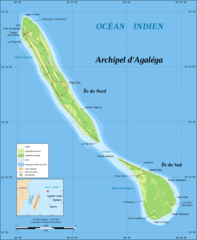
Agalega Islands Map French
2000 x 2433
- 188,515k -
png
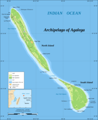
Agalega Islands Map
2000 x 2433
- 190,075k -
png