Samoa Islands, Eastern District
Samoa Islands: archipelago covering 3, 030 km² (1, 170 sq mi) in the central South Pacific, forming part of Polynesia and the wider region of Oceania
About
Quick Facts about Samoa Islands
| Country | Samoa, United States of America, American Samoa |
| State | Eastern District (American Samoa) |
| Area | 3030 km2 |
| Has part | Vailulu'u, Upolu, Manono Island |
| Latitude & Longitude | -14.0000,-171.0000 |
| Altitude | 6,096 feet / 1858 meters |
| Time Zone | UTC−11:00 |
| Local time | 12:04:56 (30th May 2026) |
Geography
Samoa Islands is located at 14°0'0"S 171°0'0"W (-14.0000000, -171.0000000).
Samoa Islands map
Click "full screen"  icon to open full mode. View satellite images
Bauman Islands, Baumann Islands, Iles des Navigateurs, Isole Dei Navigatori, Navigator Islands, Navigator's Islands, Navigators Islands, Samoa, Samoa americaine, Samoan Islands
Map & Images (more maps)
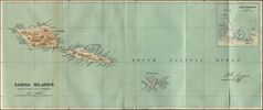
Historical Map Samoa Islands (1889)
1600 x 671
- 134,619k -
jpg