North Springfield, Virginia
North Springfield: census designated place
About
North Springfield is a CDP located in the county of Fairfax in the U.S. state of Virginia.

Quick Facts about North Springfield
| Population | 7,274 |
| Country | United States of America |
| State | Virginia (United States) |
| County | Fairfax County |
| Postal code | 22151 |
| Area | 4.03 km2 |
| Latitude & Longitude | 38.8043,-77.2047 |
| Altitude | 302 feet / 92 meters |
| Time Zone | America/New_York |
| Local time | 09:18:25 (17th July 2026) |
| Weather | 97℉ Sunny 7-days weather |

Geography
North Springfield is located at 38°48'15"N 77°12'17"W (38.8042800, -77.2047000).
North Springfield map
Best Things to Do in North Springfield
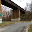
1The Orange And Alexandria Railroad Trestle
Lake Accotink Trail, North Springfield, VA 22151, United States View details
Phone: +17035693464 | Website available
Nearby Schools and Colleges
Schools and campuses linked to North Springfield, VA. Select a name to open its map and contact details.
| Code | Name | City | ZIP |
|---|---|---|---|
| 232946 | Northern Virginia Community College | Annandale (VA) | 22003-3796 |
Nearby Transit Stations (23)
Rail and bus stations connected to North Springfield, VA. Select a station to open its map and address details.
| Code | Name | Address | Type |
|---|---|---|---|
| BCV | Burke Centre | 10399 Premier Court | RAIL |
| LOR | Lorton station | 8006 Lorton Road | RAIL |
| ALX | Union Station | 110 Callahan Drive | RAIL |
| WDB | Woodbridge station | 1040 Express Way | RAIL |
| WAS | Washington Union Station | 50 Massachusetts Ave NE | RAIL |
Closest post offices linked to North Springfield.
| Post Office Name | City | ZIP |
|---|---|---|
| North Springfield Post Office | Springfield (VA) | 22151 |
Other cities in Fairfax County
Cities, towns, neighborhoods & other populated places in Fairfax County , VA. (more)
| City Name | Population | Title |
|---|---|---|
| Reston | 58,404 | Census-designated place in Fairfax County, Virginia, United States |
| McLean | 48,115 | A city in Fairfax County, Virginia. |
| Burke | 41,055 | A census-designated place in Fairfax County, Virginia. |
| Annandale | 41,008 | Census designated place in Virginia, United Stetes |
| Oakton | 34,166 | Unincorporated community in Virginia |
| Herndon | 24,573 | Town in Virginia, United States |
| Baileys Crossroads | 23,643 | Census designated place |
| Lincolnia | 22,855 | Census designated place in Fairfax County, Virginia, United States |
| West Springfield | 22,460 | City in Hampden County, Massachusetts |
| Rose Hill | 20,226 | City in Mahaska County, Iowa, United States |
| Tysons Corner | 19,627 | Unincorporated census-designated place (CDP) in Fairfax County, Virginia, United States |
| Lorton | 18,610 | Census designated place |
| Franconia | 18,245 | Census designated place |
| Idylwood | 17,288 | Census designated place |
| Vienna | 16,518 | Town in Fairfax County, Virginia |
| Wolf Trap | 16,131 | Census designated place |
Distance to Other Cities
North Springfield distances to largest Virginia cities