Metro Manila (National Capital Region), PH
Metro Manila: capital region of the Philippines
About
Quick Facts about National Capital Region
| Population | 3,966,695 |
| Country | Philippines |
| County | Bous |
| Phone Area Codes | 2 |
| Area | 611.39 km2 |
| Latitude & Longitude | 14.5833,121.0000 |
| Altitude | 10 feet / 3 meters |
| Capital | Manila |
| Establishment | November 07, 1975 (50 years ago) |
| Time Zone | Asia/Manila |
| Local time | 18:43:35 (15th July 2026) |
Geography
National Capital Region is located at 14°34'60"N 121°0'0"E (14.5833000, 121.0000000). It has 4 neighbors: Rizal, Cavite, Bulacan and Laguna.
Metro Manila map
Click "full screen"  icon to open full mode. View satellite images
Official website of National Capital Region
Official Website- Muntinlupa
- Valenzuela
- Pasay
- Pasig
- Marikina
- Las Piñas
- Navotas
- Malabon
- Makati
- San Juan
- Pateros
- Taguig
- Parañaque
- Mandaluyong
- Caloocan
- Quezon City
- Manila
Demographics
| Year | Population | % Change | Method |
|---|---|---|---|
| 1903 | 328,939 | - | census |
| 1918 | 461,166 | 28.67% | census |
| 1939 | 993,889 | 53.6% | census |
| 1948 | 1,569,128 | 36.66% | census |
| 1960 | 2,462,488 | 36.28% | census |
| 1975 | 4,970,006 | 50.45% | census |
| 1980 | 5,925,884 | 16.13% | census |
| 1990 | 7,948,392 | 25.45% | census |
| 1995 | 9,454,040 | 15.93% | census |
| 2000 | 9,932,560 | 4.82% | census |
| 2007 | 11,566,325 | 14.13% | census |
| 2010 | 11,855,975 | 2.44% | census |
| 2015 | 3,966,695 | -198.89% | 1970-05-06T00:00:00Z |
Metropolitan Manila, NCR
Map & Images (more maps)
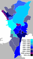
Metro Manila By Cityhood
700 x 1260
- 17,279k -
png
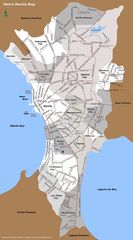
Metro Manila Map
750 x 1350
- 227,327k -
jpg
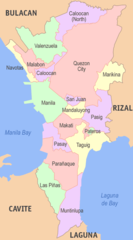
Metro Manila Political Map
500 x 900
- 30,744k -
png
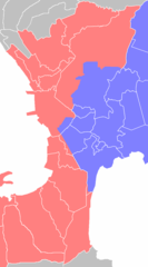
Metro Manila Water Zones
700 x 1260
- 16,906k -
png