Marmaris, Muğla
Marmaris: district of Turkey
About
Quick Facts about Marmaris
| Population | 94,247 |
| Country | Turkey |
| State | Muğla (Turkey) |
| County | Marmaris |
| Postal code | 48700 |
| Plate code | 48 |
| Area | 878.1 km2 |
| Official name | Marmaris |
| Latitude & Longitude | 36.8550,28.2742 |
| Named for | marble |
| Altitude | 23 feet / 7 meters |
| Time Zone | UTC+03:00 |
| Local time | 00:13:45 (11th July 2026) |
Geography
Marmaris is located at 36°51'18"N 28°16'27"E (36.8550000, 28.2741700).
Marmaris map
Click "full screen"  icon to open full mode. View satellite images
Official website of Marmaris
Official Website- Fürth (1995 )
- Jinan
- Ordu
Demographics
| Year | Population | % Change | Method |
|---|---|---|---|
| 2012 | 34,047 | - | census |
| 2015 | 89,630 | 62.01% | census |
| 2018 | 94,247 | 4.9% | Address Based Population Registration System |
Mararis, Marmarice, Physcus, QRQ, ma er ma li si gang, maleumaliseu, marmarys, marumarisu, mrmarys, mrmrys, Мармарис, מרמריס, ضلع مرمارس, مارماریس, مرماريس, マルマリス, 马尔马里斯港, 마르마리스
Map & Images (more maps)
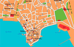
Marmaris City Map
1194 x 765
- 214,154k -
jpg