Klondyke, Arizona
Klondyke: ghost town in Graham County, Arizona
About
Klondyke is a town located in the county of Graham in the U.S. state of Arizona.
Quick Facts about Klondyke
| Country | United States of America |
| State | Arizona (United States) |
| County | Graham County |
| Latitude & Longitude | 32.8353,-110.3323 |
| Time Zone | America/Phoenix |
| Local time | 22:38:31 (9th June 2026) |
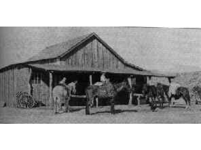
Klondyke Arizona General Store 1910 image
Geography
Klondyke is located at 32°50'7"N 110°19'56"W (32.8353400, -110.3323100).
Klondyke map
Click "full screen"  icon to open full mode. View satellite images
Nearby Schools and Colleges
Schools and campuses linked to Klondyke, AZ. Select a name to open its map and contact details.
| Code | Name | City | ZIP |
|---|---|---|---|
| 104577 | Eastern Arizona College | Thatcher (AZ) | 85552-0769 |
Nearby Transit Stations (2)
Rail and bus stations connected to Klondyke, AZ. Select a station to open its map and address details.
| Code | Name | Address | Type |
|---|---|---|---|
| TUS | Tucson | 400 North Toole Avenue | RAIL |
| BEN | Benson | 105 E. 4th Street | RAIL |
Closest post offices linked to Klondyke.
| Post Office Name | City | ZIP |
|---|---|---|
| Mammoth Post Office | Mammoth (AZ) | 85618 |
Other cities in Graham County
Cities, towns, neighborhoods & other populated places in Graham County , AZ.
| City Name | Population | Title |
|---|---|---|
| Safford | 9,951 | City in and county seat of Graham County, Arizona, United States |
| Thatcher | 5,264 | Town in Graham County, Arizona, United States |
| Swift Trail Junction | 2,935 | Census designated place |
| Pima | 2,588 | Town in Graham County, Arizona, United States |
| Bylas | 1,962 | Census-designated place |