Indore, Madhya Pradesh
Indore: Located in the western part of Madhya Pradesh, this major city is a commercial and educational hub.
About
Quick Facts about Indore
| Population | 1,994,397 |
| Country | India |
| State | Madhya Pradesh (India) |
| County | Indore |
| Postal code | 4520XX |
| Phone Area Codes | 731 |
| Area | 530 km2 |
| Latitude & Longitude | 22.7179,75.8333 |
| Official language | Hindi |
| Altitude | 1,814 feet / 553 meters |
| Capital city | Indore is capital of Indore division, Indore district, Indore State |
| Time Zone | UTC+05:30 |
| Local time | 03:15:47 (25th July 2026) |

Indore Rajwada image
Geography
Indore is located at 22°43'5"N 75°49'60"E (22.7179200, 75.8333000).
Indore map
Click "full screen"  icon to open full mode. View satellite images
Official website of Indore
Official WebsiteDemographics
| Year | Population | % Change | Method |
|---|---|---|---|
| 2011 | 1,994,397 | - | census |
IDR, Indaur, Indor, Indore Madhya Pradesh, Induras, andwr, ayndwr, idaura, indaura, indoleu, indora, indori, indoru, indura, intor, yin duo er, Індаур, Индаур, Индор, إندور, اندور, ایندور, इंदूर, इन्दोर, इन्दौर, ইন্দোর, ਇੰਦੌਰ, ઈંદોર, ଇନ୍ଦୋର, இந்தோர், ఇండోర్, ಇಂದೋರ್, ഇൻഡോർ, ინდორი, インドール, 印多尔, 인도르
Map & Images (more maps)
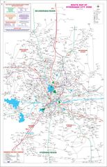
City Map of Hyderabad
1612 x 2500
- 468,649k -
jpg
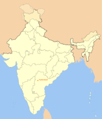
Location Map of Hyderabad
1714 x 2000
- 103,984k -
png
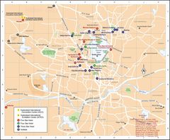
Map of Hyderabad
1800 x 1488
- 282,299k -
jpg
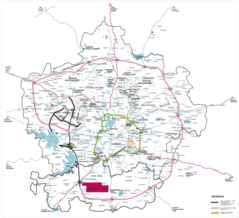
Transport Map of Hyderabad
2000 x 1823
- 543,139k -
png