Brussels, Brussels Capital
Brussels: Located in the central part of Belgium, this city serves as the country's capital and is a major European center.
About

Quick Facts about Brussels
| Population | 185,103 |
| Country | Belgium |
| State | Brussels Capital (Belgium) |
| County | Bruxelles-Capitale |
| Different from | Brussels metropolitan area, Brussels-Capital Region |
| Postal code | 1130, 1120, 1060, 1050, 1030, 1040, 1020, 1000 |
| Phone Area Codes | 02 |
| Official name | Ville de Bruxelles, Stad Brussel |
| Has part | European Quarter, Pentagon, north extension of Brussels, south extension of Brussels, Haren, Neder-Over-Heembeek, Laeken |
| Continent | Europe |
| Annual number of weddings | 693 |
| Latitude & Longitude | 50.8466,4.3528 |
| Patron saint | Michael the Archangel |
| Named for | home, marsh |
| Official language | Dutch, French |
| Altitude | 230 feet / 70 meters |
| Capital city | Brussels is capital of Flemish Region, Brussels-Capital Region, Province of Brabant, Austrian Netherlands, United States of Belgium, Flemish Community, Belgium, Dyle, United Kingdom of the Netherlands, French Community of Belgium, European Union, South Brabant, Flanders, Burgundian Netherlands, Spanish Netherlands |
| Time Zone | UTC+01:00 |
| Local time | 06:07:09 (25th July 2026) |
Bruxelles Brussels-Capital Belgium Map locator map image
Geography
Brussels is located at 50°50'48"N 4°21'10"E (50.8465974826927, 4.35277462005615). It has 7 neighbors: Yet, Zaventem, Wemmel, Vilvoorde, Machelen, Grimbergen and Saint Gilles.
Brussels map
Click "full screen"  icon to open full mode. View satellite images
Official website of Brussels
Go to Official Website Go to Official Website Go to Official Website Go to Official Website- Akhisar
- Amsterdam
- Atlanta
- Beijing (1994 )
- Berlin (1992 )
- Brasília
- Brussels
- Gabicce Mare
- Kyiv (1997 )
- Lagos
- Ljubljana
- Macau
- Madrid
- Montreal
- Moscow
- Prague
- Sofia
- Tirana
- Vilnius
- Washington, D.C.
Demographics
| Year | Population | % Change | Method |
|---|---|---|---|
| 2017 | 176,545 | - | census |
| 2018 | 179,277 | 1.52% | census |
| 2020 | 185,103 | 3.15% | census |
1000, An Bhruiseil, An Bhruiséil, Breissel, Brisel, Brisele, Briuselis, Brjuksel, Brjusel', Brjussel', Brueksel, Bruessel, Bruesszel, Bruiseal, Bruksel, Bruksela, Brukseli, Brukselo, Brusehl', Brusel, Brusela, Bruselas, Bruseles, Bruselj, Bruselo, Brusel·les, Brussel, Brussele, Brussel·les, Bruxel, Bruxelas, Bruxellae, Bruxelles, Brwsel, Bryssel, Bréissel, Brüksel, Brüssel, Brüsszel, Citta di Bruxelles, Città di Bruxelles, Kota Brusel, Βρυξέλλες, Брисел, Брусэль, Брюксел, Брюсель, Брюссель, Բրյուսել, בריסל, بروكسل, بروکسل, بريۇسسېل, ܒܪܘܟܣܠ, ब्रसेल्स, บรัสเซลส์, ბრიუსელი, ブリュッセル, 布鲁塞尔, 브뤼셀
Map & Images (more maps)
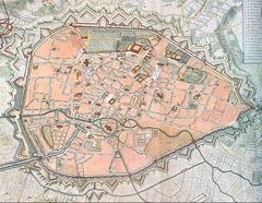
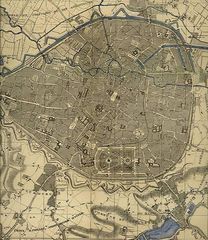
Brussels Map Rouge1745
755 x 586
- 152,201k -
jpg
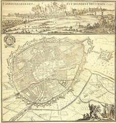
Bombardement Bruxelles 1695 01
1163 x 1233
- 480,772k -
jpg
Brussel 1555 Deventer
600 x 752
- 118,537k -
jpg
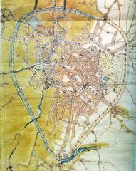
Brussels 1837 Saint Gaugericus
1362 x 1128
- 252,613k -
jpg
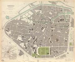
Brussels 1837 Jpeg
1362 x 1128
- 449,071k -
peg
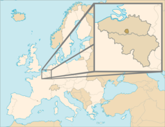
Brussels In Belgium And the European Union
920 x 704
- 47,217k -
png
Former Senne
604 x 698
- 127,225k -
jpg
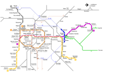
Brussels Metro Map
1600 x 1082
- 77,878k -
png

Brussels Metro Map 1
1000 x 620
- 18,763k -
png