Bochum, North Rhine-Westphalia
Bochum: Located in the Ruhr area of North Rhine-Westphalia, Bochum is a significant German city.
About
Quick Facts about Bochum
| Population | 364,628 |
| Country | Germany |
| State | North Rhine-Westphalia (Germany) |
| County | Regierungsbezirk Arnsberg |
| Postal code | 44701–44894 |
| Plate code | BO |
| Phone Area Codes | 02327, 0234 |
| Official name | Bochum |
| Continent | Europe, Eurasia |
| Latitude & Longitude | 51.4817,7.2165 |
| Male population | 177699 |
| Female population | 186929 |
| Altitude | 308 feet / 94, 100 meters |
| Time Zone | UTC+02:00, UTC+01:00 |
| Local time | 00:52:59 (26th July 2026) |
Geography
Bochum is located at 51°28'54"N 7°12'59"E (51.4816500, 7.2164800). It has 4 neighbors: Witten, Herne, Essen and Dortmund.
Bochum map
Click "full screen"  icon to open full mode. View satellite images
Official website of Bochum
Official Website- Donetsk (1987 )
- Nordhausen (1990 )
- Oviedo (1980 )
- Sheffield (1950 )
- Xuzhou (1994 )
- Wattenscheid
- Bochum-Mitte (district)
Demographics
| Year | Population | % Change | Method |
|---|---|---|---|
| 1970 | 341,935 | - | census |
| 1975 | 414,842 | 17.57% | census |
| 1980 | 400,757 | -3.51% | project management estimation |
| 1990 | 396,486 | -1.08% | census |
| 2000 | 391,147 | -1.36% | statistical updating |
| 2010 | 374,737 | -4.38% | census |
| 2011 | 373,976 | -0.2% | statistical updating |
| 2012 | 362,213 | -3.25% | project management estimation |
| 2013 | 361,734 | -0.13% | statistical updating |
| 2016 | 364,920 | 0.87% | project management estimation |
| 2017 | 365,529 | 0.17% | statistical updating |
| 2018 | 364,628 | -0.25% | census |
| 2019 | 364,628 | 0% | statistical updating |
Baukem, Bochoum, Bochumas, Bohuma, Bokhem, Bokhum, Bōkhêm, QBO, bo hong, bo khum, bofumu, bohum, bokhuma, bokhumi, bwkhm, bwkhwm, bwkwm, Μπόχουμ, Бохум, בוכום, بوخم, بوخوم, बोखुम, โบคุม, ბოხუმი, ボーフム, 波鸿, 보훔
Map & Images (more maps)
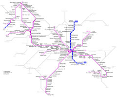
Bochum Metro Map
1184 x 984
- 31,350k -
png