Agra (Āgra), Uttar Pradesh
Agra:
About
County Snapshot
Āgra at a glance
Āgra currently has 7 quality-checked populated place pages linked on MapSof, making it easier to jump from the county overview into local city pages.
Mapped populated places
7
These counts use a stricter populated-place filter so the main lists stay focused on real city and town pages.
Uttar Pradesh counties
38
Open related pagesLargest city
BāhPopulation 1,492,584
Top linked places
Quick Facts about Āgra
| State | Uttar Pradesh (India) |
| Latitude & Longitude | 27.0833,77.9667 |
| Time Zone | Asia/Kolkata |
| Local time | 02:16:46 (25th July 2026) |
Geography
Āgra is located at 27°4'60"N 77°58'0"E (27.0833300, 77.9666700).
Agra map
Click "full screen"  icon to open full mode. View satellite images
The largest city of Āgra is Agra with a population of 1,430,055. . See all Āgra cities & populated places.
AGR, Agra District
Map & Images (more maps)
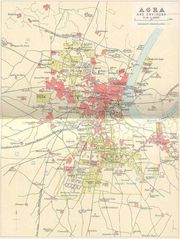
City Map of Agra
903 x 1200
- 190,187k -
jpg
Land Structure Map Tamil Nadu
1345 x 1800
- 277,289k -
jpg