Hopwood, Pennsylvania
Hopwood: census designated place
About
Hopwood is a CDP located in the county of Fayette in the U.S. state of Pennsylvania.
Quick Facts about Hopwood
| Population | 2,090 |
| Country | United States of America |
| State | Pennsylvania (United States) |
| County | Fayette County |
| Latitude & Longitude | 39.8770,-79.7020 |
| Altitude | 1,112 feet / 339 meters |
| Time Zone | America/New_York |
| Local time | 05:57:38 (15th July 2026) |
| Postal code | 15445 |
| Weather | 69℉ Mostly Clear 7-days weather |

Geography
Hopwood is located at 39°52'37"N 79°42'7"W (39.8770200, -79.7019900).
Hopwood map
Weather
Mostly clear, with a low around 69. Southwest wind around 2 mph.
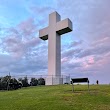
7-Day ForecastBest Things to Do in Hopwood
1The Great Cross of Christ
887 Sr2021, Hopwood, PA 15445, United States View details
Phone: +17244394912 | Website available
People born in Hopwood (1)
American freestyle skier Kristi Leskinen was born in Hopwood
Nearby Schools and Colleges
Schools and campuses linked to Hopwood, PA. Select a name to open its map and contact details.
| Code | Name | City | ZIP |
|---|---|---|---|
| 250027 | Laurel Business Institute | Uniontown (PA) | 15401 |
| 248624 | Fayette County Career & Technical Institute Practical Nursing Program | Uniontown (PA) | 15401 |
| 214759 | Pennsylvania State University-Penn State Fayette- Eberly | Lemont Furnace (PA) | 15456-1025 |
| 261861 | West Virginia Junior College-United Career Institute | Mount Braddock (PA) | 15465 |
| 211361 | California University of Pennsylvania | California (PA) | 15419-1394 |
Nearby Transit Stations (9)
Rail and bus stations connected to Hopwood, PA. Select a station to open its map and address details.
| Code | Name | Address | Type |
|---|---|---|---|
| COV | Connellsville station | North Water Street and West Peach Street | RAIL |
| GNB | Greensburg | Harrison Ave. and Seton Hill Dr. | RAIL |
| GTV | Grantsville, MD | 3000 Chestnut Ridge Road | BUS |
| LAB | Latrobe station | 329 McKinley Ave | RAIL |
| PGH | Union Station | 1100 Liberty Avenue | RAIL |
Closest post offices linked to Hopwood.
| Post Office Name | City | ZIP |
|---|---|---|
| Hopwood Post Office | Hopwood (PA) | 15445 |
| Brownfield Post Office | Brownfield (PA) | 15416 |
| Downtown Uniontown Post Office | Uniontown (PA) | 15401 |
| Uniontown Post Office | Uniontown (PA) | 15401 |
| Oliver Post Office | Oliver (PA) | 15472 |
Other cities in Fayette County
Cities, towns, neighborhoods & other populated places in Fayette County , PA. (more)
| City Name | Population | Title |
|---|---|---|
| Palmer | 21,443 | Township in Northampton County, Pennsylvania, United States of America |
| White | 15,495 | City in United States of America |
| Uniontown | 9,632 | City in Fayette County, Pennsylvania, United States |
| Collier | 8,247 | City in Pennsylvania, United States |
| Redstone | 5,241 | Township in Fayette County, Pennsylvania |
| Lynn | 4,440 | Township in Lehigh County, Pennsylvania |
| Mahoning | 4,096 | Township in southern Montour County, Pennsylvania |
| Fayette | 3,560 | City in and county seat of Fayette County, Alabama, United States |
| Hatfield | 3,323 | Borough of Pennsylvania |
| Masontown | 3,260 | Borough in Pennsylvania, United States |
| Luzerne | 2,802 | Township in Fayette County, Pennsylvania |
| East Uniontown | 2,419 | Census designated place |
| Coolspring | 2,127 | City in United States of America |
| Connellsville | 2,048 | City in Fayette County, Pennsylvania, United States |
| Oliver | 1,942 | Census-designated place (CDP) in Fayette County, Pennsylvania, United States |
| South Connellsville | 1,896 | Borough of Pennsylvania |
Distance to Other Cities
Hopwood distances to largest Pennsylvania cities