Dobson, North Carolina
Dobson: human settlement in Surry County, North Carolina, United States of America
About
Dobson is a city located in the county of Surry in the U.S. state of North Carolina. Its population at the 2010 census was 1,586 and a population density of 311 people per km². After 10 years in 2020 city had an estimated population of 1,534 inhabitants.
The city was created 135 years ago in 1890.

Quick Facts about Dobson
| Population | 1,534 (2020) |
| Country | United States of America |
| State | North Carolina (United States) |
| County | Surry County |
| Postal code | 27017 |
| Phone Area Codes | 336 |
| Area | 5.1 km2 |
| Latitude & Longitude | 36.3957,-80.7226 |
| Altitude | 1,257 feet / 383 meters |
| Capital city | Dobson is capital of Surry County |
| Establishment | January 01, 1891 (135 years ago) |
| Time Zone | Eastern Time Zone |
| Local time | 17:24:21 (16th July 2026) |
| Density | 301 Pop. per km² as of 2020 |
| Population growth | -3.39% (2010-2020) |
| Weather | 95℉ Sunny 7-days weather |
Geography
Dobson is located at 36°23'44"N 80°43'21"W (36.3956900, -80.7225700).
Dobson map
Weather
Sunny, with a high near 95. Northeast wind around 5 mph.
7-Day ForecastOfficial website of Dobson
Official WebsiteDemographics
According to census records, the population of Dobson decreased by 3.39% in 10 years.
| Year | Population | % Change | Method |
|---|---|---|---|
| 2010 | 1,586 | - | census |
| 2011 | 1,586 | 0% | estimation process |
| 2012 | 1,580 | -0.38% | estimation process |
| 2013 | 1,567 | -0.83% | estimation process |
| 2014 | 1,563 | -0.26% | estimation process |
| 2015 | 1,553 | -0.64% | estimation process |
| 2016 | 1,548 | -0.32% | estimation process |
| 2017 | 1,548 | 0% | estimation process |
| 2018 | 1,543 | -0.32% | estimation process |
| 2019 | 1,539 | -0.26% | estimation process |
| 2020 | 1,534 | -0.33% | estimation process |
Demographic Facts
| Estimated population as of July 1, 2019 : | 23,408 |
| Based on demographic estimates as of April 1, 2010 : | 22,851 |
| Based on demographic estimates as of 1 April 2010 : | 2.4% |
| April 1, 2020 Population : | 25,326 |
| April 1, 2010 Population : | 22,844 |
| People under 5 years old, percentage : | 6.0% |
| People under 18 years old, percentage : | 23.7% |
| People over 65 (%) : | 12.0% |
| Female persons, % : | 52.1% |
| White only, percent : | 54.4% |
| Black or African American alone, percent : | 13.3% |
| American Indian and Alaska Native only, % : | 0.4% |
| Asians alone % : | 20.7% |
| Only Native Hawaiians and Other Pacific Islanders, % : | 0.2% |
| % of people who have participated in two or more races : | 2.8% |
| % of Hispanic or Latino : | 39.8% |
| White people, not Hispanic or Latino people, make up the majority of the population. : | 26.5% |
| 2015-2019 Veterans : | 832 |
| Percentage of foreign-born people, 2015-2019 : | 31.9% |
| Rate of owner-occupied housing units, 2015-2019 : | 57.7% |
Economic Facts
| Rate of owner-occupied housing units, 2015-2019 : | 57.7% |
| Owner-occupied housing unit median value, 2015-2019 : | $272,200 |
| From 2015 to 2019, the median selected monthly owner costs - with a mortgage : | $2,115 |
| Monthly owner costs, without a mortgage, at the median, 2015-2019 : | $879 |
| 2015-2019 median gross rent : | $1,492 |
| 2015-2019 Households : | 7,925 |
| Population per household, 2015-2019 : | 2.98 |
| Living in the same house a year ago, percentage of people aged one year and up, 2015-2019 : | 87.0% |
| Languages other than English spoken at home, as a percentage of people aged 5 and up, 2015-2019 : | 56.2% |
| Households with computers, %, 2015-2019 : | 85.5% |
| Percentage of households with a broadband Internet subscription, 2015-2019 : | 71.1% |
| Percentage of people aged 25 and up with a high school diploma or higher, 2015-2019 : | 85.6% |
| Bachelor's degree or higher, proportion of people aged 25 and up, 2015-2019 : | 24.3% |
| Percentage of people under the age of 65 who have a disability, 2015-2019 : | 7.2% |
| Persons under the age of 65 who do not have health insurance, as a percentage : | 11.0% |
| Total civilian labor force, percent of population aged 16 and up, 2015-2019 : | 64.8% |
| Female labor force participation in the civilian labor force, as a percentage of the population aged 16 and up, 2015-2019 : | 56.3% |
| Total sales of lodging and food services in 2012 ($1,000) : | 16,201 |
| Manufacturers' total shipments in 2012 ($1,000) : | 423,353 |
| 2012 total retail sales ($1,000) : | 153,905 |
| 2012 total retail sales per capita : | $6,396 |
| Mean commute time to work (in minutes), workers aged 16 and up, 2015-2019 : | 31.4 |
| 2015-2019 median household income (in 2019 dollars) : | $73,347 |
| Income per capita in the previous 12 months (in 2019 dollars), 2015-2019 : | $28,285 |
| Percentage of people living in poverty : | 13.1% |
| Total number of businesses in 2012 : | 2,053 |
| Men-owned businesses in 2012 : | 1,455 |
| Women-owned businesses in 2012 : | 537 |
| Minority-owned businesses in 2012 : | 1,405 |
| Non-minority-owned businesses in 2012 : | 594 |
| Veteran-owned businesses in 2012 : | 118 |
| Nonveteran-owned businesses in 2012 : | 1,880 |
| 2010 population per square mile : | 5,171.1 |
| 2010 land area in square miles : | 4.42 |
Best Things to Do in Dobson
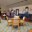
1Shelton Vineyards
286 Cabernet Ln, Dobson, NC 27017, United States View details
Phone: +13363664724 | Website available

2The Farm Dobson
769 Bray Ford Rd, Dobson, NC 27017, United States View details
Phone: +13368175208 | Website available

3Stony Knoll Vineyards
1143 Stony Knoll Rd, Dobson, NC 27017, United States View details
Phone: +13363745752 | Website available
Where to Eat in Dobson
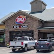
1Dairy Queen Grill & Chill
2359 Zephyr Rd, Dobson, NC 27017, United States View details
Phone: +13363539475 | Website available
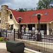
2Rockford General Store
5174 Rockford Rd, Dobson, NC 27017, United States View details
Phone: +13363745317 | Website available

3Herrera Vineyards
231 Vineyard Ln, Dobson, NC 27017, United States View details
Phone: +13363746337 | Website available
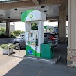
4bp
2359 Zephyr Rd, Dobson, NC 27017, United States View details
Phone: +13363539470 | Website available
Where to Stay in Dobson
1Hampton Inn & Suites Dobson
150 Charlestowne Dr, Dobson, NC 27017, United States View details
Phone: +13363539400 | Website available

People born in Dobson (6)
People born in Dobson, including politician Alonzo Dillard Folger, United States Air Force general Caleb V. Haynes, baseball player Clem Llewellyn, .
More notable people
- Mike Richardson (American professional soccer player) he was born in 02/09/1985
- Roy Hampton Park (American journalist) he was born in 15/09/1910
- Frank Jenkins (American musician) he was born in 01/01/1888
Nearby Schools and Colleges
Schools and campuses linked to Dobson, NC. Select a name to open its map and contact details.
| Code | Name | City | ZIP |
|---|---|---|---|
| 199768 | Surry Community College | Dobson (NC) | 27017-8432 |
Nearby Transit Stations (8)
Rail and bus stations connected to Dobson, NC. Select a station to open its map and address details.
| Code | Name | Address | Type |
|---|---|---|---|
| WNS | Winston-Salem, North Carolina | 100 West 5th Street | BUS |
| UWS | Winston-Salem State Univ, Winston-Salem, North Car | 601 South Martin Luther King, Jr. Dr | BUS |
| LEX | Lexington | Center St. and railroad tracks | RAIL |
| HPT | High Point | 100 West High St | RAIL |
| SAL | Salisbury | Depot and Liberty Sts. | RAIL |
Closest post offices linked to Dobson.
| Post Office Name | City | ZIP |
|---|---|---|
| Dobson Post Office | Dobson (NC) | 27017 |
Other cities in Surry County
Cities, towns, neighborhoods & other populated places in Surry County , NC.
| City Name | Population | Title |
|---|---|---|
| Mount Airy | 10,175 | City in Surry County, North Carolina, United States |
| Elkin | 4,001 | Town in Surry and Wilkes counties in North Carolina, United States |
| Flat Rock | 1,556 | Township in Surry County, North Carolina |
| Toast | 1,450 | Township in Surry County, North Carolina |
| Pilot Mountain | 1,408 | City in Piedmont Triad, North Carolina, United States of America |
| White Plains | 1,074 | Township in Surry County, North Carolina |
Distance to Other Cities
Dobson distances to largest North Carolina cities