How far is South Yuba City, CA from Laguna, CA?
The driving distance from South Yuba City, CA to Laguna, CA is about 55.3 miles (89 km), with a travel time of about 00h 59m by car.
- The straight-line flight distance is about 49.5 miles (79.6 km).
- For a round trip, plan for roughly 01h 59m of driving time before adding stops, traffic, or weather delays.
- A comfortable departure window is usually 8:00 AM to 10:00 AM PDT.
Reverse, save, or send this route
This route works well as a day trip with time at the destination. Copy the route link, send it to another device, or print a clean version before you head out.
This route works well as a day trip with time at the destination.
Flight Distance
Driving Distance
Gas Cost Calculator
Leave and Arrive Planner
Pick a departure time to see your estimated arrival and same-day return window.
Drive time stays fixed at 00h 59m.
A morning start gives you useful time at the destination and keeps the return out of the late evening.
You are leaving earlier than the recommended window, which gives you extra margin for breaks and traffic.
Halfway Point
A useful midpoint for breaks, coffee, or meeting in the middle.
Census-designated place in Sacramento County, California
Route Weather Snapshot
Check the forecast at both ends before you head out.
Sunny
Driving Route Map
The map below follows the saved road route between South Yuba City and Laguna.
Turn-by-Turn Driving Directions
Step-by-step road directions between South Yuba City and Laguna.
-
1
Start on the route
154 m · 39 sec
-
2
Turn right onto Richland Road
1540 ft · 46 sec · Richland Road
-
3
Turn right
33.2 mi · 39 min
-
4
Merge slight left onto Westside Freeway
6.2 mi · 7 min · Westside Freeway
-
5
Take the exit slight right toward US 50: South Lake Tahoe, San Francisco
2110 ft · 28 sec
-
6
Keep slight left to continue on US 50 East: Fresno
1936 ft · 33 sec
-
7
Keep slight left to continue on US 50 East: Fresno
3077 ft · 1 min
-
8
Merge slight left onto Capital City Freeway
1.2 mi · 1 min · Capital City Freeway
-
9
Keep slight right to continue on Capital City Freeway
1383 ft · 18 sec · Capital City Freeway
-
10
Take the exit slight right toward CA 99 South: Fresno
2281 ft · 34 sec
-
11
Merge slight left onto South Sacramento Freeway
7.4 mi · 9 min · South Sacramento Freeway
-
12
Take the exit slight right toward Cosumnes River Boulevard, Calvine Road
1505 ft · 38 sec
-
13
Turn right onto Cosumnes River Boulevard
1370 ft · 27 sec · Cosumnes River Boulevard
-
14
Turn left onto Bruceville Road
2.7 mi · 5 min · Bruceville Road
-
15
Turn right onto Seasons Drive
1694 ft · 50 sec · Seasons Drive
-
16
Turn right onto November Drive
541 ft · 30 sec · November Drive
-
17
At the end of the road, turn left onto Mapleview Way
47 m · 12 sec · Mapleview Way
-
18
Turn left onto Fall Breeze Court
56 m · 8 sec · Fall Breeze Court
-
19
Arrive at your destination
0 m · 1 sec · Fall Breeze Court
Car Route Details
A richer read on the saved driving route between South Yuba City and Laguna.
Turn-heavy local drive
The route has frequent decision points for its length, so lane choice and turn timing will matter more than cruising speed.
Longest stretch
Turn right
33.2 mi · 00h 39m
Route Summary
A quick read on whether this route feels easy, ambitious, or worth planning around.
A comfortable day-trip route
This route works well as a day trip. You can leave in the morning, spend meaningful time at the destination, and still return the same day.
Sunny leaving South Yuba City and Sunny near Laguna.
Trip Questions
Direct answers travelers usually want before committing to the drive.
How long does it take to drive from South Yuba City to Laguna?
The road trip is about 55.3 miles (89 km) and usually takes 00h 59m in normal driving conditions.
Is this a same-day trip or an overnight route?
This route works well as a day trip. You can leave in the morning, spend meaningful time at the destination, and still return the same day.
What is the halfway point on this route?
Rio Linda is a useful midpoint, sitting about 27.1 miles from South Yuba City and 28.3 miles from Laguna.
How much longer is the road route than the straight-line distance?
The direct path is about 49.5 miles (79.6 km), while the road route adds roughly 5.8 extra miles because roads do not follow the straight air line.
When is the best time to leave for this route?
A good departure window is usually 8:00 AM to 10:00 AM PDT. If you want a more comfortable same-day return, try to leave by 4:30 PM PDT.
How much will gas cost for this route?
Using about 28.3 MPG, regular gas is estimated at $11.25 one way or $22.50 round trip. Estimated CO2 is about 17.3 kg one way.
What should you check before leaving?
Before you leave, expect Sunny around South Yuba City and Sunny near Laguna.
Stop Ideas Near Rio Linda
Useful break, food, and waypoint ideas within about 15 miles of the route midpoint.
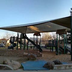
North Point Park
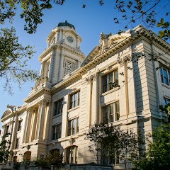
Sacramento City Hall
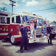
West Sacramento Fire Station 44

City of Sacramento
Transit and Meeting Points
Useful pickup, handoff, or rendezvous points close to Rio Linda.
Sacramento (State Capitol), California
Sacramento Valley Station
Roseville station
Rocklin
Flight Path Map
This map shows the direct air route between South Yuba City and Laguna. Straight-line distance: 49.44 mi (79.56 km).

#1 South Yuba City
Town
| Population | 15,217 |
| Coordinates | 39.1165600, -121.6391300 |
| Altitude | 16 |
| Country | United States |

#2 Laguna
A city located in Orange County, California.
| Population | 1,370,232 |
| Coordinates | 38.4210200, -121.4238400 |
| Altitude | 9 |
| Country | United States |
End: Fall Breeze Court (-121.42396, 38.421309)
Estimated Travel Time
Distance: 89 km by road
| Speed | Time |
|---|---|
| 30 mph (48.3 km/h) | 01h 50m |
| 40 mph (64.37 km/h) | 01h 22m |
| 50 mph (80.47 km/h) | 01h 06m |
| 60 mph (96.56 km/h) | 00h 55m |
| 70 mph (112.65 km/h) | 00h 47m |
| 80 mph (129 km/h) | 00h 41m |
Fuel, Round Trip and CO2
Estimated fuel cost and emissions for this route.
| Fuel | $/gal | One way | Round trip |
|---|---|---|---|
| Regular gas | $5.77 | $11.25 | $22.50 |
| Mid-grade | $6.07 | $11.83 | $23.66 |
| Premium | $6.24 | $12.17 | $24.35 |
| Diesel | $7.57 | $14.76 | $29.51 |
Assumes 8.3 L/100 km (about 28.3 MPG). CO2 is an estimate and varies by vehicle, fuel blend, traffic, and terrain.
Prices in California · Jul 26, 2026
Distance to Other Cities
Planning a road trip? See the full trip guide on Trip.ovh — stops, fuel costs, weather, and departure timing.