How far is Rhode Island, TX from Penitas, TX?
The driving distance from Rhode Island, TX to Penitas, TX is about 518.7 miles (834.7 km), with a travel time of about 09h 07m by car.
- The straight-line flight distance is about 408.4 miles (657.2 km).
- For a round trip, plan for roughly 18h 15m of driving time before adding stops, traffic, or weather delays.
- A comfortable departure window is usually 6:00 AM to 7:30 AM CDT.
Reverse, save, or send this route
This drive is better planned with a longer stop or an overnight stay. Copy the route link, send it to another device, or print a clean version before you head out.
This drive is better planned with a longer stop or an overnight stay.
Flight Distance
Driving Distance
Gas Cost Calculator
Leave and Arrive Planner
Pick a departure time to see your estimated arrival and same-day return window.
Drive time stays fixed at 09h 07m.
Starting early still helps, but most travelers will want a longer stop or an overnight stay on a route this long.
You are leaving earlier than the recommended window, which gives you extra margin for breaks and traffic.
Halfway Point
A useful midpoint for breaks, coffee, or meeting in the middle.
Route Weather Snapshot
Check the forecast at both ends before you head out.
Slight Chance Rain Showers
Sunny
Driving Route Map
The map below follows the saved road route between Rhode Island and Penitas.
Turn-by-Turn Driving Directions
Step-by-step road directions between Rhode Island and Penitas.
-
1
Start on County Road 161
3 m · 7 sec · County Road 161
-
2
Turn left onto East FM 833
1.5 km · 1 min · East FM 833
-
3
Turn right onto North State Highway 75
16 m · 3 sec · North State Highway 75
-
4
Turn left onto West FM 833
1.1 km · 2 min · West FM 833
-
5
Continue on Farm-to-Market Road 833
1990 ft · 56 sec · Farm-to-Market Road 833
-
6
Take the ramp right
2067 ft · 50 sec
-
7
Merge slight left
19.9 mi · 20 min
-
8
Take the exit slight right toward TX 31: Athens, Waco
1599 ft · 42 sec
-
9
Turn left onto South Interstate 45
2149 ft · 50 sec · South Interstate 45
-
10
Turn left onto Corsicana Bypass
5.6 mi · 6 min · Corsicana Bypass
-
11
At the end of the road, turn left onto West State Highway 31
18.8 mi · 21 min · West State Highway 31
-
12
Continue on Hubbard Bypass
5.5 mi · 6 min · Hubbard Bypass
-
13
Continue on State Highway 31
17.2 mi · 17 min · State Highway 31
-
14
Continue on East US Highway 84
2.5 mi · 3 min · East US Highway 84
-
15
Continue on Bellmead Drive
2.6 mi · 5 min · Bellmead Drive
-
16
Turn straight onto East Waco Drive
2288 ft · 1 min · East Waco Drive
-
17
Turn left onto North Jack Kultgen Expressway
158 m · 12 sec · North Jack Kultgen Expressway
-
18
Take the ramp straight toward I 35 South, US 77 South
1524 ft · 37 sec
-
19
Merge slight left onto North Jack Kultgen Expressway
6.1 mi · 7 min · North Jack Kultgen Expressway
-
20
Continue on Purple Heart Trail
37.9 mi · 39 min · Purple Heart Trail
-
21
Keep slight left
26.5 mi · 27 min
-
22
Take the exit slight right toward TX 130 Toll South: San Antonio
1.1 km · 56 sec
-
23
Continue straight
86.1 mi · 1 hr 19 min
-
24
Keep slight right to continue on I 10 West: San Antonio
3262 ft · 1 min
-
25
Merge slight left
11.1 mi · 11 min
-
26
Continue straight
9.4 mi · 9 min
-
27
Keep slight left
12 mi · 13 min
-
28
Keep slight right to continue on Connally Loop
1.4 mi · 2 min · Connally Loop
-
29
Merge slight left onto Connally Loop
6.7 mi · 7 min · Connally Loop
-
30
Take the exit slight right toward I 37, US 281 North: San Antonio, Corpus Christi
1184 ft · 29 sec
-
31
Keep slight left to continue on I 37 South: Corpus Christi
2457 ft · 1 min
-
32
Merge slight left
60.5 mi · 1 hr 1 min
-
33
Take the exit slight right toward US 281 South
15.2 mi · 19 min
-
34
Keep slight left to continue on South Nueces Street
66.2 mi · 1 hr 10 min · South Nueces Street
-
35
Keep slight left
9.5 mi · 10 min
-
36
Keep slight left to continue on Falfurrias Expressway
55.8 mi · 59 min · Falfurrias Expressway
-
37
Keep slight left
17.6 mi · 19 min
-
38
Take the exit slight right toward US 281 South, TX 495: Pharr
1.3 km · 2 min
-
39
Merge slight right
15.6 mi · 18 min
-
40
Take the exit slight right toward US 83 West: Frontage Road
826 ft · 20 sec
-
41
Turn straight onto West Expressway 83
1238 ft · 25 sec · West Expressway 83
-
42
Keep slight left to continue on East Expressway 83
1.2 mi · 2 min · East Expressway 83
-
43
Turn left onto Penitas Street
1.5 km · 2 min · Penitas Street
-
44
Turn left
59 m · 14 sec
-
45
Arrive at your destination
0 m · 1 sec
Car Route Details
A richer read on the saved driving route between Rhode Island and Penitas.
Long-distance drive
This route is long enough that fuel, rest stops, weather, and timing matter more than any single maneuver.
TX 130 Toll South
Continue straight
86.1 mi · 01h 19m
Route Summary
A quick read on whether this route feels easy, ambitious, or worth planning around.
Better with a longer stop
This route is long enough that most travelers will be better off planning an overnight stay or a more deliberate stop window.
Slight Chance Rain Showers leaving Rhode Island and Sunny near Penitas.
Trip Questions
Direct answers travelers usually want before committing to the drive.
How long does it take to drive from Rhode Island to Penitas?
The road trip is about 518.7 miles (834.7 km) and usually takes 09h 07m in normal driving conditions.
Is this a same-day trip or an overnight route?
This route is long enough that most travelers will be better off planning an overnight stay or a more deliberate stop window.
What is the halfway point on this route?
Converse is a useful midpoint, sitting about 259.8 miles from Rhode Island and 258.9 miles from Penitas.
How much longer is the road route than the straight-line distance?
The direct path is about 408.4 miles (657.2 km), while the road route adds roughly 110.3 extra miles because roads do not follow the straight air line.
When is the best time to leave for this route?
A good departure window is usually 6:00 AM to 7:30 AM CDT. Starting early still helps, but most travelers will want a longer stop or an overnight stay on a route this long.
How much will gas cost for this route?
Using about 28.3 MPG, regular gas is estimated at $69.16 one way or $138.31 round trip. Estimated CO2 is about 162.6 kg one way.
What should you check before leaving?
Before you leave, expect Slight Chance Rain Showers around Rhode Island and Sunny near Penitas.
Stop Ideas Near Converse
Useful break, food, and waypoint ideas within about 15 miles of the route midpoint.
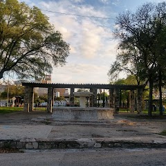
Piazza Italia Park

Schertz EMS

Converse City Hall

Municipal Plaza
Transit and Meeting Points
Useful pickup, handoff, or rendezvous points close to Converse.
San Antonio Station
San Marcos Station
Austin
Flight Path Map
This map shows the direct air route between Rhode Island and Penitas. Straight-line distance: 408.35 mi (657.18 km).
#1 Rhode Island
Rhode Island is a place in Texas, United States.
| Population | 0 |
| Coordinates | 31.8154400, -96.2313600 |
| Altitude | 119 |
| Country | United States |

#2 Penitas
City in Texas, United States
| Population | 4,596 |
| Coordinates | 26.2306300, -98.4447400 |
| Altitude | 44 |
| Country | United States |
End: Penitas (-98.44474, 26.23063)
Estimated Travel Time
Distance: 835 km by road
| Speed | Time |
|---|---|
| 30 mph (48.3 km/h) | 17h 16m |
| 40 mph (64.37 km/h) | 12h 58m |
| 50 mph (80.47 km/h) | 10h 22m |
| 60 mph (96.56 km/h) | 08h 38m |
| 70 mph (112.65 km/h) | 07h 24m |
| 80 mph (129 km/h) | 06h 28m |
Fuel, Round Trip and CO2
Estimated fuel cost and emissions for this route.
| Fuel | $/gal | One way | Round trip |
|---|---|---|---|
| Regular gas | $3.78 | $69.16 | $138.31 |
| Mid-grade | $4.25 | $77.81 | $155.62 |
| Premium | $4.59 | $84.02 | $168.03 |
| Diesel | $3.99 | $73.07 | $146.14 |
Assumes 8.3 L/100 km (about 28.3 MPG). CO2 is an estimate and varies by vehicle, fuel blend, traffic, and terrain.
Prices in Texas · Jul 24, 2026
Distance to Other Cities
Planning a road trip? See the full trip guide on Trip.ovh — stops, fuel costs, weather, and departure timing.