How far is Ravenna, 05 from Middlefield, OH?
The driving distance from Ravenna, 05 to Middlefield, OH is about 958 miles (1541.7 km), with a travel time of about 19h 16m by car.
- The straight-line flight distance is about 4446.5 miles (7155.9 km).
- For a round trip, plan for roughly 38h 32m of driving time before adding stops, traffic, or weather delays.
- A comfortable departure window is usually 6:00 AM to 7:30 AM CEST.
Reverse, save, or send this route
This drive is better planned with a longer stop or an overnight stay. Copy the route link, send it to another device, or print a clean version before you head out.
This drive is better planned with a longer stop or an overnight stay.
Flight Distance
Driving Distance
Gas Cost Calculator
Leave and Arrive Planner
Pick a departure time to see your estimated arrival and same-day return window.
Drive time stays fixed at 19h 16m.
Starting early still helps, but most travelers will want a longer stop or an overnight stay on a route this long.
You are leaving earlier than the recommended window, which gives you extra margin for breaks and traffic.
Halfway Point
A useful midpoint for breaks, coffee, or meeting in the middle.
Town in Connecticut, United States
Route Weather Snapshot
Check the forecast at both ends before you head out.
Mostly Cloudy
Driving Route Map
The map below follows the saved road route between Ravenna and Middlefield.
Turn-by-Turn Driving Directions
Step-by-step road directions between Ravenna and Middlefield.
-
1
Start on Route 774
3 mi · 5 min · Route 774
-
2
Turn left
2.5 mi · 4 min
-
3
Continue on FDR International Memorial Bridge
880 ft · 18 sec · FDR International Memorial Bridge
-
4
Continue on State Route 189
154 m · 10 sec · State Route 189
-
5
Continue on Washington Street
1900 ft · 40 sec · Washington Street
-
6
Continue on Main Street
1.3 km · 2 min · Main Street
-
7
Continue on County Road
9.3 mi · 14 min · County Road
-
8
Continue on Lubec Road
1 km · 2 min · Lubec Road
-
9
At the end of the road, turn left onto Route 1
9.5 mi · 13 min · Route 1
-
10
Continue on Main Street
3.1 mi · 5 min · Main Street
-
11
Turn slight right onto River Road
127 m · 7 sec · River Road
-
12
Continue on Main Street
4.2 mi · 6 min · Main Street
-
13
Continue on Dublin Street
2.3 mi · 3 min · Dublin Street
-
14
Continue on Outer Dublin Street
1249 ft · 21 sec · Outer Dublin Street
-
15
Continue on Harrington Road
3.3 mi · 5 min · Harrington Road
-
16
Continue on Route 1
14 mi · 21 min · Route 1
-
17
Turn straight onto Main Street
2696 ft · 46 sec · Main Street
-
18
Continue on Kennedy Highway
1084 ft · 18 sec · Kennedy Highway
-
19
Continue on US Highway 1A
3 mi · 5 min · US Highway 1A
-
20
Continue on Kennedy Highway
4.1 mi · 6 min · Kennedy Highway
-
21
Continue on Bridge Street
1721 ft · 34 sec · Bridge Street
-
22
At the end of the road, turn left onto Main Street
1.8 mi · 3 min · Main Street
-
23
Continue on US Highway 1
27.7 mi · 41 min · US Highway 1
-
24
Continue on Downeast Highway
1.1 mi · 2 min · Downeast Highway
-
25
Keep slight right to continue on Downeast Highway
140 m · 11 sec · Downeast Highway
-
26
Continue on High Street
1268 ft · 36 sec · High Street
-
27
Turn left onto Foster Street
2227 ft · 1 min · Foster Street
-
28
At the end of the road, turn right onto Water Street
1.1 km · 1 min · Water Street
-
29
Turn left onto West Main Street
806 ft · 10 sec · West Main Street
-
30
Keep slight right to continue on Main Street
85 m · 4 sec · Main Street
-
31
Continue on Bucksport Road
8.5 mi · 10 min · Bucksport Road
-
32
Continue on Acadia Highway
9.4 mi · 11 min · Acadia Highway
-
33
Continue on Route 1
1.6 km · 1 min · Route 1
-
34
Continue on Main Street
41 m · 9 sec · Main Street
-
35
Turn left onto Route 1
682 ft · 17 sec · Route 1
-
36
Continue on US Highway 1
1.2 mi · 3 min · US Highway 1
-
37
Continue on Route 1
13.4 mi · 16 min · Route 1
-
38
Continue on Searsport Avenue
2.7 mi · 5 min · Searsport Avenue
-
39
Continue on Route 1
1.1 km · 1 min · Route 1
-
40
Take the exit slight right
1414 ft · 39 sec
-
41
Keep slight right
114 m · 12 sec
-
42
Merge slight left onto Belmont Avenue
3.9 mi · 5 min · Belmont Avenue
-
43
Continue on Augusta Road
4.8 mi · 5 min · Augusta Road
-
44
Continue on Belfast Augusta Road East
3.4 mi · 4 min · Belfast Augusta Road East
-
45
Continue on Acadia Highway
4 mi · 4 min · Acadia Highway
-
46
Continue on Belfast Augusta Road
17.6 mi · 21 min · Belfast Augusta Road
-
47
Continue on Belfast Road
1077 ft · 17 sec · Belfast Road
-
48
Continue on North Belfast Avenue
8.1 mi · 12 min · North Belfast Avenue
-
49
Turn left onto North Belfast Avenue
1.6 km · 2 min · North Belfast Avenue
-
50
At the end of the road, turn left onto Bangor Street
2936 ft · 53 sec · Bangor Street
-
51
Enter the roundabout and take exit 2 toward Cony Circle
49 m · 3 sec · Memorial Drive
-
52
Exit the rotary onto Memorial Drive
1.1 km · 2 min · Memorial Drive
-
53
Enter the roundabout and take exit 3 toward Memorial Circle
122 m · 7 sec · State Street
-
54
Exit the rotary onto State Street
1007 ft · 19 sec · State Street
-
55
Turn right onto Capitol Street
1.3 km · 1 min · Capitol Street
-
56
Turn straight onto Armory Street
915 ft · 20 sec · Armory Street
-
57
Turn left onto Western Avenue
1.1 km · 1 min · Western Avenue
-
58
Take the exit slight right toward I 95: Portland, Waterville, Bangor
1829 ft · 44 sec
-
59
Keep slight left to continue on I-95 South: Portland, Kittery
3262 ft · 1 min
-
60
Merge slight left onto Maine Turnpike
5.9 mi · 6 min · Maine Turnpike
-
61
Keep slight right to continue on I 295 South, ME 9, ME 126: Gardiner, Brunswick
50.5 mi · 59 min
-
62
Keep slight left
2.6 mi · 4 min
-
63
Merge slight left onto Maine Turnpike
53 mi · 59 min · Maine Turnpike
-
64
Keep slight left to continue on Blue Star Turnpike
7.7 mi · 9 min · Blue Star Turnpike
-
65
Keep slight right to continue on I 495 South: Worcester
30.6 mi · 36 min
-
66
Take the exit slight right toward US 3: Burlington, Nashua New Hampshire
1068 ft · 14 sec
-
67
Keep slight left to continue on US 3: Burlington, Nashua New Hampshire
1320 ft · 17 sec
-
68
Keep slight left
1931 ft · 25 sec
-
69
Keep slight left to continue on I 495 South: Marlboro
2589 ft · 34 sec
-
70
Merge slight left
23.4 mi · 27 min
-
71
Take the exit slight right toward I 290 West: Worcester
2148 ft · 1 min
-
72
Merge slight left
19.6 mi · 25 min
-
73
Take the exit slight right toward MA 12 South: Webster
703 ft · 23 sec
-
74
Turn left onto Oxford Street
142 m · 10 sec · Oxford Street
-
75
At the end of the road, turn right onto Southbridge Street
136 m · 10 sec · Southbridge Street
-
76
Take the exit slight right toward I 90
2072 ft · 1 min
-
77
Keep slight left to continue on I 90 West
2915 ft · 1 min
-
78
Merge slight left onto Massachusetts Turnpike
11.2 mi · 13 min · Massachusetts Turnpike
-
79
Keep slight right to continue on Wilbur Cross Highway
33.6 mi · 40 min · Wilbur Cross Highway
-
80
Keep slight right
8 mi · 9 min
-
81
Keep slight right
15.1 mi · 19 min
-
82
Keep slight left
45.8 mi · 56 min
-
83
Keep slight right
128.8 mi · 2 hr 32 min
-
84
Take the exit slight left toward I 81 South: Wilkes-Barre
1.2 mi · 2 min
-
85
Merge slight left onto American Legion Memorial Highway
35 mi · 42 min · American Legion Memorial Highway
-
86
Take the exit slight right toward I-80 West: Bloomsburg
1.1 km · 1 min
-
87
Merge slight left onto Keystone Shortway
267.4 mi · 4 hr 49 min · Keystone Shortway
-
88
Take the exit slight right toward SR 11 North: Warren, Ashtabula
2651 ft · 58 sec
-
89
Merge slight left
5.1 mi · 6 min
-
90
Take the exit slight left toward SR 82 West: Warren
1.1 km · 2 min
-
91
Merge slight right
10.4 mi · 13 min
-
92
Take the exit slight right toward US 422
820 ft · 20 sec
-
93
Keep slight left to continue on US 422 East: Warren
128 m · 12 sec
-
94
Turn right onto Parkman Road Northwest
1.7 mi · 2 min · Parkman Road Northwest
-
95
Continue on US Route 422 Northwest
4.9 mi · 7 min · US Route 422 Northwest
-
96
Continue on US Route 422 NW
1.4 mi · 2 min · US Route 422 NW
-
97
Continue on US 422
1.9 mi · 3 min · US 422
-
98
Continue on Main Market Road
2.6 mi · 4 min · Main Market Road
-
99
Turn right onto Madison Road
4.6 mi · 8 min · Madison Road
-
100
Turn left onto Old State Road
1.1 mi · 2 min · Old State Road
-
101
Continue on South State Avenue
1.4 km · 2 min · South State Avenue
-
102
Turn left onto West High Street
67 m · 9 sec · West High Street
-
103
Turn left
8 m · 2 sec
-
104
Arrive at your destination
0 m · 1 sec
Car Route Details
A richer read on the saved driving route between Ravenna and Middlefield.
Long-distance drive
This route is long enough that fuel, rest stops, weather, and timing matter more than any single maneuver.
Keystone Shortway
Merge slight left onto Keystone Shortway
267 mi · 04h 49m
Route Summary
A quick read on whether this route feels easy, ambitious, or worth planning around.
Better with a longer stop
This route is long enough that most travelers will be better off planning an overnight stay or a more deliberate stop window.
Mostly Cloudy near Middlefield.
Trip Questions
Direct answers travelers usually want before committing to the drive.
How long does it take to drive from Ravenna to Middlefield?
The road trip is about 958 miles (1541.7 km) and usually takes 19h 16m in normal driving conditions.
Is this a same-day trip or an overnight route?
This route is long enough that most travelers will be better off planning an overnight stay or a more deliberate stop window.
What is the halfway point on this route?
Newtown is a useful midpoint, sitting about 472.2 miles from Ravenna and 485.7 miles from Middlefield.
How much longer is the road route than the straight-line distance?
The direct path is about 4446.5 miles (7155.9 km), while the road route adds roughly 0 extra miles because roads do not follow the straight air line.
When is the best time to leave for this route?
A good departure window is usually 6:00 AM to 7:30 AM CEST. Starting early still helps, but most travelers will want a longer stop or an overnight stay on a route this long.
Do you cross a time zone on this route?
Yes. There is about a 6 hour time difference between Ravenna and Middlefield, so arrival and return times should be read in local time.
What should you check before leaving?
Before arriving, the latest forecast around Middlefield is Mostly Cloudy.
Stop Ideas Near Newtown
Useful break, food, and waypoint ideas within about 15 miles of the route midpoint.

Danbury Fair
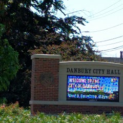
Danbury City Hall
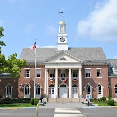
Edmond Town Hall
Transit and Meeting Points
Useful pickup, handoff, or rendezvous points close to Newtown.
Bridgeport
Union Station
Wallingford station
Meriden Transit Center
Flight Path Map
This map shows the direct air route between Ravenna and Middlefield. Straight-line distance: 4446.5 mi (7155.95 km).

#2 Middlefield
Town in Massachusetts, USA
| Population | 4,466 |
| Coordinates | 41.4620000, -81.0737100 |
| Altitude | 343 |
| Country | United States |
End: Middlefield (-81.07371, 41.462)
Estimated Travel Time
Distance: 1542 km by road
| Speed | Time |
|---|---|
| 30 mph (48.3 km/h) | 31h 55m |
| 40 mph (64.37 km/h) | 23h 57m |
| 50 mph (80.47 km/h) | 19h 09m |
| 60 mph (96.56 km/h) | 15h 57m |
| 70 mph (112.65 km/h) | 13h 41m |
| 80 mph (129 km/h) | 11h 57m |