How far is Lewistown, MT from Havre, MT?
The driving distance from Lewistown, MT to Havre, MT is about 175.7 miles (282.8 km), with a travel time of about 03h 10m by car.
- The straight-line flight distance is about 103.5 miles (166.5 km).
- For a round trip, plan for roughly 06h 21m of driving time before adding stops, traffic, or weather delays.
- A comfortable departure window is usually 6:00 AM to 8:00 AM MDT.
Reverse, save, or send this route
This drive is better planned with a longer stop or an overnight stay. Copy the route link, send it to another device, or print a clean version before you head out.
This drive is better planned with a longer stop or an overnight stay.
Flight Distance
Driving Distance
Gas Cost Calculator
Leave and Arrive Planner
Pick a departure time to see your estimated arrival and same-day return window.
Drive time stays fixed at 03h 10m.
An early departure helps you fit a real stop into the day without turning the return into a late-night drive.
You are leaving earlier than the recommended window, which gives you extra margin for breaks and traffic.
Halfway Point
A useful midpoint for breaks, coffee, or meeting in the middle.
Town in Cascade County, Montana, United States
Route Weather Snapshot
Check the forecast at both ends before you head out.
Chance Rain Showers
Showers And Thunderstorms
Driving Route Map
The map below follows the saved road route between Lewistown and Havre.
Turn-by-Turn Driving Directions
Step-by-step road directions between Lewistown and Havre.
-
1
Start on 6th Avenue South
121 m · 23 sec · 6th Avenue South
-
2
Turn left onto West Main Street
1.3 km · 2 min · West Main Street
-
3
Continue on US Highway 87
1.5 mi · 2 min · US Highway 87
-
4
At the end of the road, turn left onto US Highway 87
14.7 mi · 16 min · US Highway 87
-
5
Continue straight
64.3 mi · 1 hr 10 min
-
6
Turn slight right
1588 ft · 21 sec
-
7
Enter the roundabout and take exit 2 toward the route
52 m · 2 sec
-
8
Exit the roundabout
557 ft · 7 sec
-
9
Continue straight
19.3 mi · 21 min
-
10
Turn right onto 57th Street South
1.6 mi · 2 min · 57th Street South
-
11
Continue on River Drive North
3.4 mi · 5 min · River Drive North
-
12
Turn right onto 15th Street North
108.4 mi · 2 hr · 15th Street North
-
13
Turn right
3 mi · 4 min
-
14
Turn right onto 1st Avenue
1661 ft · 1 min · 1st Avenue
-
15
Turn right onto 5th Street
128 m · 20 sec · 5th Street
-
16
Turn right onto Montana Avenue
49 m · 7 sec · Montana Avenue
-
17
Arrive at your destination
0 m · 1 sec · Montana Avenue
Car Route Details
A richer read on the saved driving route between Lewistown and Havre.
Highway-focused drive
Most of the mileage stays on named highways, so the important moments are ramps, exits, merges, and the final local approach.
15th Street North
Turn right onto 15th Street North
108 mi · 02h 00m
Route Summary
A quick read on whether this route feels easy, ambitious, or worth planning around.
A longer out-and-back drive
This is still possible in one day, but it becomes a long driving day. Leaving early and planning your stop window matters more here.
Chance Rain Showers leaving Lewistown and Showers And Thunderstorms near Havre.
Trip Questions
Direct answers travelers usually want before committing to the drive.
How long does it take to drive from Lewistown to Havre?
The road trip is about 175.7 miles (282.8 km) and usually takes 03h 10m in normal driving conditions.
Is this a same-day trip or an overnight route?
This is still possible in one day, but it becomes a long driving day. Leaving early and planning your stop window matters more here.
What is the halfway point on this route?
Great Falls is a useful midpoint, sitting about 108.8 miles from Lewistown and 66.9 miles from Havre.
How much longer is the road route than the straight-line distance?
The direct path is about 103.5 miles (166.5 km), while the road route adds roughly 72.2 extra miles because roads do not follow the straight air line.
When is the best time to leave for this route?
A good departure window is usually 6:00 AM to 8:00 AM MDT. If you want a more comfortable same-day return, try to leave by 10:38 AM MDT.
How much will gas cost for this route?
Using about 28.3 MPG, regular gas is estimated at $24.14 one way or $48.27 round trip. Estimated CO2 is about 55.1 kg one way.
What should you check before leaving?
Before you leave, expect Chance Rain Showers around Lewistown and Showers And Thunderstorms near Havre.
Stop Ideas Near Great Falls
Useful break, food, and waypoint ideas within about 15 miles of the route midpoint.
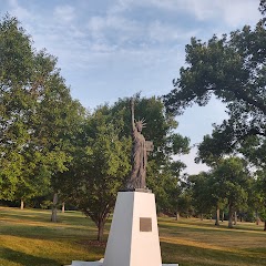
Statue of Liberty Replica

The Great Falls Civic Center
Cascade County Treasurer
Transit and Meeting Points
Useful pickup, handoff, or rendezvous points close to Great Falls.
Shelby
Flight Path Map
This map shows the direct air route between Lewistown and Havre. Straight-line distance: 103.46 mi (166.51 km).

#1 Lewistown
City in Montana, United States
| Population | 5,905 |
| Coordinates | 47.0624700, -109.4282400 |
| Altitude | 1203 |
| Country | United States |

#2 Havre
City in Hill County, Montana, United States
| Population | 9,706 |
| Coordinates | 48.5500000, -109.6840900 |
| Altitude | 771 |
| Country | United States |
End: Montana Avenue (-109.683848, 48.549988)
Estimated Travel Time
Distance: 283 km by road
| Speed | Time |
|---|---|
| 30 mph (48.3 km/h) | 05h 51m |
| 40 mph (64.37 km/h) | 04h 23m |
| 50 mph (80.47 km/h) | 03h 30m |
| 60 mph (96.56 km/h) | 02h 55m |
| 70 mph (112.65 km/h) | 02h 30m |
| 80 mph (129 km/h) | 02h 11m |
Fuel, Round Trip and CO2
Estimated fuel cost and emissions for this route.
| Fuel | $/gal | One way | Round trip |
|---|---|---|---|
| Regular gas | $3.89 | $24.14 | $48.27 |
| Mid-grade | $4.23 | $26.23 | $52.46 |
| Premium | $4.55 | $28.20 | $56.41 |
| Diesel | $5.41 | $33.55 | $67.11 |
Assumes 8.3 L/100 km (about 28.3 MPG). CO2 is an estimate and varies by vehicle, fuel blend, traffic, and terrain.
Prices in Montana · Jun 11, 2026
Distance to Other Cities
Planning a road trip? See the full trip guide on Trip.ovh — stops, fuel costs, weather, and departure timing.