How far is Jacksonville, NC from Summerfield, NC?
The driving distance from Jacksonville, NC to Summerfield, NC is about 208.8 miles (336 km), with a travel time of about 04h 11m by car.
- The straight-line flight distance is about 171.7 miles (276.3 km).
- For a round trip, plan for roughly 08h 22m of driving time before adding stops, traffic, or weather delays.
- A comfortable departure window is usually 6:00 AM to 8:00 AM EDT.
Reverse, save, or send this route
This drive is better planned with a longer stop or an overnight stay. Copy the route link, send it to another device, or print a clean version before you head out.
This drive is better planned with a longer stop or an overnight stay.
Flight Distance
Driving Distance
Gas Cost Calculator
Leave and Arrive Planner
Pick a departure time to see your estimated arrival and same-day return window.
Drive time stays fixed at 04h 11m.
An early departure helps you fit a real stop into the day without turning the return into a late-night drive.
You are leaving earlier than the recommended window, which gives you extra margin for breaks and traffic.
Halfway Point
A useful midpoint for breaks, coffee, or meeting in the middle.
Town in North Carolina
Route Weather Snapshot
Check the forecast at both ends before you head out.
Showers And Thunderstorms Likely
Slight Chance Rain Showers then Slight Chance Showers And Thunderstorms
Driving Route Map
The map below follows the saved road route between Jacksonville and Summerfield.
Turn-by-Turn Driving Directions
Step-by-step road directions between Jacksonville and Summerfield.
-
1
Start on Marine Boulevard
1.1 mi · 2 min · Marine Boulevard
-
2
Keep slight right to continue on Richlands Highway
1.4 mi · 2 min · Richlands Highway
-
3
Continue on Richlands Highway
5 mi · 8 min · Richlands Highway
-
4
Turn left onto Catherine Lake Road
14.4 mi · 21 min · Catherine Lake Road
-
5
Turn right onto Jackson Store Road
6.3 mi · 9 min · Jackson Store Road
-
6
At the end of the road, turn left onto Hallsville Road
4.4 mi · 6 min · Hallsville Road
-
7
At the end of the road, turn right
5.1 mi · 7 min
-
8
Turn left onto D S Williams Road
1.6 km · 1 min · D S Williams Road
-
9
Turn left onto South Kenansville Bypass
3.9 mi · 5 min · South Kenansville Bypass
-
10
Take the exit right
59.8 mi · 1 hr 4 min
-
11
Keep slight left
86.1 mi · 1 hr 39 min
-
12
Keep slight right
1871 ft · 25 sec
-
13
Take the exit slight right toward I 785 North, I 840 West
1 km · 1 min
-
14
Merge slight left onto Greensboro Urban Loop
13.6 mi · 16 min · Greensboro Urban Loop
-
15
Take the exit slight right toward US 220: Battleground Avenue
1704 ft · 42 sec
-
16
Keep slight right to continue on US 220 North
124 m · 14 sec
-
17
Turn right onto Battleground Avenue
3.9 mi · 6 min · Battleground Avenue
-
18
Keep slight right to continue on Battleground Avenue
1.5 mi · 2 min · Battleground Avenue
-
19
Turn left onto Oak Ridge Road
43 m · 9 sec · Oak Ridge Road
-
20
Arrive at your destination
0 m · 1 sec · Oak Ridge Road
Car Route Details
A richer read on the saved driving route between Jacksonville and Summerfield.
Straightforward drive
The saved road route has a manageable number of maneuvers and should be easy to follow with normal attention to signs.
South Kenansville Bypass
Keep slight left
86.1 mi · 01h 39m
Route Summary
A quick read on whether this route feels easy, ambitious, or worth planning around.
A longer out-and-back drive
This is still possible in one day, but it becomes a long driving day. Leaving early and planning your stop window matters more here.
Showers And Thunderstorms Likely leaving Jacksonville and Slight Chance Rain Showers then Slight Chance Showers And Thunderstorms near Summerfield.
Trip Questions
Direct answers travelers usually want before committing to the drive.
How long does it take to drive from Jacksonville to Summerfield?
The road trip is about 208.8 miles (336 km) and usually takes 04h 11m in normal driving conditions.
Is this a same-day trip or an overnight route?
This is still possible in one day, but it becomes a long driving day. Leaving early and planning your stop window matters more here.
What is the halfway point on this route?
Clayton is a useful midpoint, sitting about 104.4 miles from Jacksonville and 104.5 miles from Summerfield.
How much longer is the road route than the straight-line distance?
The direct path is about 171.7 miles (276.3 km), while the road route adds roughly 37.1 extra miles because roads do not follow the straight air line.
When is the best time to leave for this route?
A good departure window is usually 6:00 AM to 8:00 AM EDT. If you want a more comfortable same-day return, try to leave by 8:38 AM EDT.
How much will gas cost for this route?
Using about 28.3 MPG, regular gas is estimated at $29.19 one way or $58.39 round trip. Estimated CO2 is about 65.5 kg one way.
What should you check before leaving?
Before you leave, expect Showers And Thunderstorms Likely around Jacksonville and Slight Chance Rain Showers then Slight Chance Showers And Thunderstorms near Summerfield.
Stop Ideas Near Clayton
Useful break, food, and waypoint ideas within about 15 miles of the route midpoint.
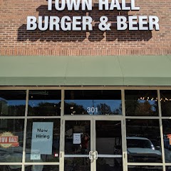
Town Hall Burger and Beer

Garner Town Hall
Clayton Utilities
Angier Police Department And Town Hall
Transit and Meeting Points
Useful pickup, handoff, or rendezvous points close to Clayton.
Selma–Smithfield
Raleigh Union Station
North Carolina State Fair station
Cary
Flight Path Map
This map shows the direct air route between Jacksonville and Summerfield. Straight-line distance: 171.7 mi (276.33 km).

#1 Jacksonville
The most populous city in Onslow County, North Carolina.
| Population | 76,284 |
| Coordinates | 34.7540500, -77.4302400 |
| Altitude | 4 |
| Country | United States |

#2 Summerfield
Town of the United States
| Population | 11,502 |
| Coordinates | 36.2087500, -79.9047600 |
| Altitude | 276 |
| Country | United States |
End: Summerfield (-79.90476, 36.20875)
Estimated Travel Time
Distance: 336 km by road
| Speed | Time |
|---|---|
| 30 mph (48.3 km/h) | 06h 57m |
| 40 mph (64.37 km/h) | 05h 13m |
| 50 mph (80.47 km/h) | 04h 10m |
| 60 mph (96.56 km/h) | 03h 28m |
| 70 mph (112.65 km/h) | 02h 58m |
| 80 mph (129 km/h) | 02h 36m |
Fuel, Round Trip and CO2
Estimated fuel cost and emissions for this route.
| Fuel | $/gal | One way | Round trip |
|---|---|---|---|
| Regular gas | $3.96 | $29.19 | $58.39 |
| Mid-grade | $4.43 | $32.64 | $65.28 |
| Premium | $4.78 | $35.21 | $70.43 |
| Diesel | $5.62 | $41.45 | $82.90 |
Assumes 8.3 L/100 km (about 28.3 MPG). CO2 is an estimate and varies by vehicle, fuel blend, traffic, and terrain.
Prices in North Carolina · Jul 14, 2026
Distance to Other Cities
Planning a road trip? See the full trip guide on Trip.ovh — stops, fuel costs, weather, and departure timing.