How far is Concord, NC from Edneyville, NC?
The driving distance from Concord, NC to Edneyville, NC is about 128.5 miles (206.8 km), with a travel time of about 02h 40m by car.
- The straight-line flight distance is about 99.1 miles (159.5 km).
- For a round trip, plan for roughly 05h 21m of driving time before adding stops, traffic, or weather delays.
- A comfortable departure window is usually 8:00 AM to 10:00 AM EDT.
Reverse, save, or send this route
This route works well as a day trip with time at the destination. Copy the route link, send it to another device, or print a clean version before you head out.
This route works well as a day trip with time at the destination.
Flight Distance
Driving Distance
Gas Cost Calculator
Leave and Arrive Planner
Pick a departure time to see your estimated arrival and same-day return window.
Drive time stays fixed at 02h 40m.
A morning start gives you useful time at the destination and keeps the return out of the late evening.
You are leaving earlier than the recommended window, which gives you extra margin for breaks and traffic.
Halfway Point
A useful midpoint for breaks, coffee, or meeting in the middle.
City in and the county seat of Cleveland County, North Carolina, United States
Route Weather Snapshot
Check the forecast at both ends before you head out.
Mostly Sunny then Chance Showers And Thunderstorms
Showers And Thunderstorms Likely
Driving Route Map
The map below follows the saved road route between Concord and Edneyville.
Turn-by-Turn Driving Directions
Step-by-step road directions between Concord and Edneyville.
-
1
Start on Spring Street Southwest
125 m · 20 sec · Spring Street Southwest
-
2
Turn left onto Cabarrus Avenue West
1.4 km · 2 min · Cabarrus Avenue West
-
3
Enter the roundabout and take exit 2 toward Cabarrus Avenue West
26 m · 2 sec · Cabarrus Avenue West
-
4
Exit the roundabout onto Cabarrus Avenue West
1 mi · 2 min · Cabarrus Avenue West
-
5
Turn left onto Concord Parkway South
6.7 mi · 10 min · Concord Parkway South
-
6
Continue on North Tryon Street
1 mi · 2 min · North Tryon Street
-
7
Take the ramp right toward I 485 Outer North
1573 ft · 38 sec
-
8
Merge slight left onto Governor James G Martin Freeway
2414 ft · 30 sec · Governor James G Martin Freeway
-
9
Continue on H Allen Tate Jr Highway
7.9 mi · 8 min · H Allen Tate Jr Highway
-
10
Continue on Craig Lawing Freeway
10.3 mi · 11 min · Craig Lawing Freeway
-
11
Take the exit slight right toward I 85, US 29, US 74: Greensboro, Spartanburg, Wilkinson Boulevard
2308 ft · 56 sec
-
12
Keep slight right to continue on I 85 South: Gastonia, Spartanburg
1.4 km · 2 min
-
13
Merge slight left
19.1 mi · 23 min
-
14
Take the exit slight right toward US 74 West: Kings Mountain, Shelby
3242 ft · 50 sec
-
15
Continue on Senator J. Ollie Harris Highway
7.6 mi · 9 min · Senator J. Ollie Harris Highway
-
16
Continue on Andrew Jackson Highway
1.8 mi · 3 min · Andrew Jackson Highway
-
17
Continue on East Dixon Boulevard
12 mi · 17 min · East Dixon Boulevard
-
18
Take the ramp straight toward West Dixon Boulevard
15.7 mi · 18 min · West Dixon Boulevard
-
19
Continue on Lieutenant Governor Walter H Dalton Highway
18.3 mi · 20 min · Lieutenant Governor Walter H Dalton Highway
-
20
Merge slight left onto Andrew Jackson Highway
16.1 mi · 19 min · Andrew Jackson Highway
-
21
Take the exit slight right toward US 64 East: Bat Cave
1907 ft · 47 sec
-
22
Turn straight onto Chimney Rock Road
6.9 mi · 11 min · Chimney Rock Road
-
23
Turn left
8 m · 2 sec
-
24
Arrive at your destination
0 m · 1 sec
Car Route Details
A richer read on the saved driving route between Concord and Edneyville.
Highway-focused drive
Most of the mileage stays on named highways, so the important moments are ramps, exits, merges, and the final local approach.
I 85 South
Merge slight left
19.1 mi · 00h 23m
Route Summary
A quick read on whether this route feels easy, ambitious, or worth planning around.
A comfortable day-trip route
This route works well as a day trip. You can leave in the morning, spend meaningful time at the destination, and still return the same day.
Mostly Sunny then Chance Showers And Thunderstorms leaving Concord and Showers And Thunderstorms Likely near Edneyville.
Trip Questions
Direct answers travelers usually want before committing to the drive.
How long does it take to drive from Concord to Edneyville?
The road trip is about 128.5 miles (206.8 km) and usually takes 02h 40m in normal driving conditions.
Is this a same-day trip or an overnight route?
This route works well as a day trip. You can leave in the morning, spend meaningful time at the destination, and still return the same day.
What is the halfway point on this route?
Shelby is a useful midpoint, sitting about 64.2 miles from Concord and 64.3 miles from Edneyville.
How much longer is the road route than the straight-line distance?
The direct path is about 99.1 miles (159.5 km), while the road route adds roughly 29.4 extra miles because roads do not follow the straight air line.
When is the best time to leave for this route?
A good departure window is usually 8:00 AM to 10:00 AM EDT. If you want a more comfortable same-day return, try to leave by 1:08 PM EDT.
How much will gas cost for this route?
Using about 28.3 MPG, regular gas is estimated at $17.98 one way or $35.97 round trip. Estimated CO2 is about 40.3 kg one way.
What should you check before leaving?
Before you leave, expect Mostly Sunny then Chance Showers And Thunderstorms around Concord and Showers And Thunderstorms Likely near Edneyville.
Stop Ideas Near Shelby
Useful break, food, and waypoint ideas within about 15 miles of the route midpoint.

Downtown Shelby Fountain Park
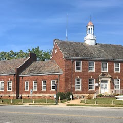
Shelby City Hall
Transit and Meeting Points
Useful pickup, handoff, or rendezvous points close to Shelby.
Gastonia
Spartanburg
Charlotte
Kannapolis
Flight Path Map
This map shows the direct air route between Concord and Edneyville. Straight-line distance: 99.09 mi (159.47 km).

#1 Concord
The most populous city in Cabarrus County, North Carolina.
| Population | 98,500 |
| Coordinates | 35.4088800, -80.5815800 |
| Altitude | 228 |
| Country | United States |
#2 Edneyville
Township in Henderson County, North Carolina
| Population | 2,367 |
| Coordinates | 35.3940100, -82.3409500 |
| Altitude | 684 |
| Country | United States |
End: Edneyville (-82.34095, 35.39401)
Estimated Travel Time
Distance: 207 km by road
| Speed | Time |
|---|---|
| 30 mph (48.3 km/h) | 04h 16m |
| 40 mph (64.37 km/h) | 03h 12m |
| 50 mph (80.47 km/h) | 02h 34m |
| 60 mph (96.56 km/h) | 02h 08m |
| 70 mph (112.65 km/h) | 01h 50m |
| 80 mph (129 km/h) | 01h 36m |
Fuel, Round Trip and CO2
Estimated fuel cost and emissions for this route.
| Fuel | $/gal | One way | Round trip |
|---|---|---|---|
| Regular gas | $3.96 | $17.98 | $35.97 |
| Mid-grade | $4.43 | $20.11 | $40.22 |
| Premium | $4.78 | $21.69 | $43.38 |
| Diesel | $5.62 | $25.53 | $51.07 |
Assumes 8.3 L/100 km (about 28.3 MPG). CO2 is an estimate and varies by vehicle, fuel blend, traffic, and terrain.
Prices in North Carolina · Jul 19, 2026
Distance to Other Cities
Planning a road trip? See the full trip guide on Trip.ovh — stops, fuel costs, weather, and departure timing.