How far is China Grove, TX from San Antonio, TX?
Fastest route
This route from China Grove, Texas, to San Antonio, Texas is approximately 13.5 miles (about 21.7 kilometers) long and will take around 18 minutes to drive. Here are some tips and directions to help you navigate the journey:
Directions
-
Get on I-410 N in San Antonio: Head northwest on US-87 N/Rigsby Ave toward Rigsby Ave. Pass by Jack in the Box (on the right in 2.5 mi). Then, take a slight right toward I-410 Access Rd/SE Loop 410 Acc Rd and continue onto I-410 N.
-
Merge onto I-35 S: After driving on I-410 N for a while, take I-35 S and follow the signs for Laredo.
-
Take exit 157A toward Lexington Ave/Main Ave/San Pedro Ave: Keep left on I-35 S and take exit 157A.
-
Drive to N Flores St: Once you've taken the exit, use the left lane to take the exit toward I-35 S. Then, keep left and merge onto I-35 S.
-
Turn left onto N Flores St: Finally, turn left onto N Flores St to reach your destination in San Antonio.
Tips & Suggestions
- 🚗 Drive Safely: Ensure your safety and the safety of others by obeying traffic rules and driving responsibly.
- ⛽ Check Fuel: Before starting the journey, check your fuel level and consider refueling if necessary.
- 🚧 Watch for Road Signs: Pay attention to road signs for exits, turns, and speed limits to stay on the right track.
- 📱 GPS Navigation: Use a GPS navigation app or device to make the trip easier and avoid getting lost.
- 🕑 Plan for Traffic: Depending on the time of day, traffic may vary, so plan accordingly to avoid delays.
- 🍴 Pack Snacks: If it's a long drive, pack some snacks and water to stay refreshed during the journey.
- 🚙 Vehicle Maintenance: Ensure your vehicle is in good condition and perform basic checks before leaving.
Reverse, save, or send this route
This is an easy same-day return drive. Copy the route link, send it to another device, or print a clean version before you head out.
This is an easy same-day return drive.
Flight Distance
Driving Distance
Gas Cost Calculator
Leave and Arrive Planner
Pick a departure time to see your estimated arrival and same-day return window.
Drive time stays fixed at 00h 20m.
This is a short drive, so your comfort window is wide. Traffic and current weather matter more than the clock.
You are leaving earlier than the recommended window, which gives you extra margin for breaks and traffic.
Halfway Point
A useful midpoint for breaks, coffee, or meeting in the middle.
City in Bexar County, Texas, United States
Route Weather Snapshot
Check the forecast at both ends before you head out.
Showers And Thunderstorms Likely
Showers And Thunderstorms Likely
Driving Route Map
The map below follows the saved road route between China Grove and San Antonio.
Turn-by-Turn Driving Directions
Step-by-step road directions between China Grove and San Antonio.
-
1
Start on US Highway 87 East
1156 ft · 25 sec · US Highway 87 East
-
2
Continue on US Highway 87 East
1.6 km · 2 min · US Highway 87 East
-
3
Continue on Rigsby Avenue
4.7 mi · 8 min · Rigsby Avenue
-
4
Turn slight right onto Roland Avenue
3196 ft · 1 min · Roland Avenue
-
5
Turn left onto I 10 West, US 90 West
1271 ft · 31 sec
-
6
Merge slight left onto Jose Lopez Freeway
1.6 mi · 2 min · Jose Lopez Freeway
-
7
Take the exit slight right toward I 37, US 281: Corpus Christi, Johnson City
644 ft · 16 sec
-
8
Keep slight right to continue on I 37 North, US 281 North: Johnson City
1883 ft · 46 sec
-
9
Merge slight left onto William J Bordelon Freeway
1.2 mi · 1 min · William J Bordelon Freeway
-
10
Take the exit slight right toward Commerce Street, Downtown, The Alamo
1358 ft · 33 sec
-
11
Turn straight onto Interstate 37 South
116 m · 12 sec · Interstate 37 South
-
12
Turn left onto East Commerce Street
1.4 km · 2 min · East Commerce Street
-
13
Turn left onto Military Plaza
119 m · 16 sec · Military Plaza
-
14
Turn left onto Dolorosa Street
100 m · 8 sec · Dolorosa Street
-
15
Arrive at your destination
0 m · 1 sec · Dolorosa Street
Car Route Details
A richer read on the saved driving route between China Grove and San Antonio.
Turn-heavy local drive
The route has frequent decision points for its length, so lane choice and turn timing will matter more than cruising speed.
Rigsby Avenue
Continue on Rigsby Avenue
4.68 mi · 00h 08m
Route Summary
A quick read on whether this route feels easy, ambitious, or worth planning around.
A short regional drive
This route is short enough to handle as a quick errand, commute, or easy same-day return without much planning overhead.
Showers And Thunderstorms Likely leaving China Grove and Showers And Thunderstorms Likely near San Antonio.
Trip Questions
Direct answers travelers usually want before committing to the drive.
How long does it take to drive from China Grove to San Antonio?
The road trip is about 14.4 miles (23.2 km) and usually takes 00h 20m in normal driving conditions.
Is this a same-day trip or an overnight route?
This route is short enough to handle as a quick errand, commute, or easy same-day return without much planning overhead.
What is the halfway point on this route?
Kirby is a useful midpoint, sitting about 5.7 miles from China Grove and 8.7 miles from San Antonio.
How much longer is the road route than the straight-line distance?
The direct path is about 9.1 miles (14.6 km), while the road route adds roughly 5.3 extra miles because roads do not follow the straight air line.
When is the best time to leave for this route?
A good departure window is usually 7:00 AM to 7:00 PM CDT. If you want a more comfortable same-day return, try to leave by 7:50 PM CDT.
How much will gas cost for this route?
Using about 28.3 MPG, regular gas is estimated at $1.93 one way or $3.85 round trip. Estimated CO2 is about 4.5 kg one way.
What should you check before leaving?
Before you leave, expect Showers And Thunderstorms Likely around China Grove and Showers And Thunderstorms Likely near San Antonio.
Stop Ideas Near Kirby
Useful break, food, and waypoint ideas within about 15 miles of the route midpoint.
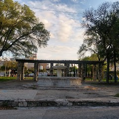
Piazza Italia Park
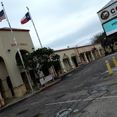
Converse City Hall

Municipal Plaza
Transit and Meeting Points
Useful pickup, handoff, or rendezvous points close to Kirby.
San Antonio Station
San Marcos Station
Austin
Flight Path Map
This map shows the direct air route between China Grove and San Antonio. Straight-line distance: 9.05 mi (14.56 km).
#1 China Grove
City in Texas, United States of America
| Population | 1,314 |
| Coordinates | 29.3888500, -98.3489000 |
| Altitude | 199 |
| Country | United States |

#2 San Antonio
The seventh most populous city in the United States and the center of the San Antonio metropolitan area.
| Population | 1,567,118 |
| Coordinates | 29.4241200, -98.4936300 |
| Altitude | 198 |
| Country | United States |
End: Dolorosa Street (-98.493645, 29.424163)
Estimated Travel Time
Distance: 23 km by road
| Speed | Time |
|---|---|
| 30 mph (48.3 km/h) | 00h 28m |
| 40 mph (64.37 km/h) | 00h 21m |
| 50 mph (80.47 km/h) | 00h 17m |
| 60 mph (96.56 km/h) | 00h 14m |
| 70 mph (112.65 km/h) | 00h 12m |
| 80 mph (129 km/h) | 00h 10m |
Fuel, Round Trip and CO2
Estimated fuel cost and emissions for this route.
| Fuel | $/gal | One way | Round trip |
|---|---|---|---|
| Regular gas | $3.78 | $1.93 | $3.85 |
| Mid-grade | $4.25 | $2.17 | $4.34 |
| Premium | $4.59 | $2.34 | $4.68 |
| Diesel | $3.99 | $2.04 | $4.07 |
Assumes 8.3 L/100 km (about 28.3 MPG). CO2 is an estimate and varies by vehicle, fuel blend, traffic, and terrain.
Prices in Texas · Jul 14, 2026
Distance to Other Cities
Planning a road trip? See the full trip guide on Trip.ovh — stops, fuel costs, weather, and departure timing.