How far is Aberdeen, NC from Chapel Hill, NC?
The driving distance from Aberdeen, NC to Chapel Hill, NC is about 255.3 miles (410.8 km), with a travel time of about 04h 34m by car.
- The straight-line flight distance is about 192.7 miles (310.1 km).
- For a round trip, plan for roughly 09h 08m of driving time before adding stops, traffic, or weather delays.
- A comfortable departure window is usually 6:00 AM to 8:00 AM EDT.
Reverse, save, or send this route
This drive is better planned with a longer stop or an overnight stay. Copy the route link, send it to another device, or print a clean version before you head out.
This drive is better planned with a longer stop or an overnight stay.
Flight Distance
Driving Distance
Gas Cost Calculator
Leave and Arrive Planner
Pick a departure time to see your estimated arrival and same-day return window.
Drive time stays fixed at 04h 34m.
An early departure helps you fit a real stop into the day without turning the return into a late-night drive.
You are leaving earlier than the recommended window, which gives you extra margin for breaks and traffic.
Halfway Point
A useful midpoint for breaks, coffee, or meeting in the middle.
City in Gaston County, North Carolina, United States of America
Route Weather Snapshot
Check the forecast at both ends before you head out.
Chance Showers And Thunderstorms
Rain Showers Likely then Partly Sunny
Driving Route Map
The map below follows the saved road route between Aberdeen and Chapel Hill.
Turn-by-Turn Driving Directions
Step-by-step road directions between Aberdeen and Chapel Hill.
-
1
Start on West South Street
19 m · 10 sec · West South Street
-
2
Turn left onto South Sandhills Boulevard
25.6 mi · 29 min · South Sandhills Boulevard
-
3
Turn right onto East Green Street
1.5 km · 1 min · East Green Street
-
4
At the end of the road, turn right onto Broad Avenue
15.5 mi · 21 min · Broad Avenue
-
5
Continue on East Caswell Street
2.4 mi · 5 min · East Caswell Street
-
6
Continue on Salisbury Street
1.1 km · 1 min · Salisbury Street
-
7
Continue on W. Cliff Martin Highway
6.5 mi · 9 min · W. Cliff Martin Highway
-
8
Keep slight right to continue on W. Cliff Martin Highway
6.3 mi · 9 min · W. Cliff Martin Highway
-
9
Continue on Carroll M. Edwards Highway
2.5 mi · 3 min · Carroll M. Edwards Highway
-
10
Continue on East Marshville Boulevard
2.9 mi · 5 min · East Marshville Boulevard
-
11
Continue on Carroll M. Edwards Highway
2247 ft · 35 sec · Carroll M. Edwards Highway
-
12
Keep slight left to continue on Monroe Expressway
18.4 mi · 21 min · Monroe Expressway
-
13
Merge slight right onto Independence Boulevard
7.1 mi · 10 min · Independence Boulevard
-
14
Continue on East Independence Expressway
5.4 mi · 7 min · East Independence Expressway
-
15
Continue on East Independence Boulevard
1.1 km · 45 sec · East Independence Boulevard
-
16
Merge slight left onto John Belk Freeway
2.3 mi · 3 min · John Belk Freeway
-
17
Take the exit straight toward NC 27: Freedom Drive
2.5 mi · 4 min
-
18
Take the ramp slight left
1678 ft · 41 sec
-
19
Merge slight left
24.1 mi · 30 min
-
20
Take the exit slight right toward US 74 West: Kings Mountain, Shelby
3242 ft · 50 sec
-
21
Continue on Senator J. Ollie Harris Highway
7.6 mi · 9 min · Senator J. Ollie Harris Highway
-
22
Continue on Andrew Jackson Highway
1.8 mi · 3 min · Andrew Jackson Highway
-
23
Continue on East Dixon Boulevard
12 mi · 17 min · East Dixon Boulevard
-
24
Take the ramp straight toward West Dixon Boulevard
15.7 mi · 18 min · West Dixon Boulevard
-
25
Continue on Lieutenant Governor Walter H Dalton Highway
18.3 mi · 20 min · Lieutenant Governor Walter H Dalton Highway
-
26
Merge slight left onto Andrew Jackson Highway
37.8 mi · 46 min · Andrew Jackson Highway
-
27
Take the exit slight right toward Westgate
920 ft · 16 sec
-
28
Turn straight onto Patton Avenue
821 ft · 14 sec · Patton Avenue
-
29
Take the ramp straight toward Westgate
48 m · 3 sec
-
30
Merge slight left onto Billy Graham Freeway
1502 ft · 26 sec · Billy Graham Freeway
-
31
Take the exit slight left toward I 26 West, US 19 North, US 23 North, US 70 West: Weaverville, Mars Hill
8.4 mi · 11 min
-
32
Take the exit slight right toward US 25 North, US 70 West: Marshall
21.3 mi · 33 min
-
33
Continue straight
3.5 mi · 6 min
-
34
Turn right onto Guntertown Road
2.2 mi · 5 min · Guntertown Road
-
35
Continue on Chapel Hill Road
1.6 mi · 6 min · Chapel Hill Road
-
36
Turn left
8 m · 2 sec
-
37
Arrive at your destination
0 m · 1 sec
Car Route Details
A richer read on the saved driving route between Aberdeen and Chapel Hill.
Highway-focused drive
Most of the mileage stays on named highways, so the important moments are ramps, exits, merges, and the final local approach.
Andrew Jackson Highway
Merge slight left onto Andrew Jackson Highway
37.8 mi · 00h 46m
Route Summary
A quick read on whether this route feels easy, ambitious, or worth planning around.
A longer out-and-back drive
This is still possible in one day, but it becomes a long driving day. Leaving early and planning your stop window matters more here.
Chance Showers And Thunderstorms leaving Aberdeen and Rain Showers Likely then Partly Sunny near Chapel Hill.
Trip Questions
Direct answers travelers usually want before committing to the drive.
How long does it take to drive from Aberdeen to Chapel Hill?
The road trip is about 255.3 miles (410.8 km) and usually takes 04h 34m in normal driving conditions.
Is this a same-day trip or an overnight route?
This is still possible in one day, but it becomes a long driving day. Leaving early and planning your stop window matters more here.
What is the halfway point on this route?
Kings Mountain is a useful midpoint, sitting about 127.8 miles from Aberdeen and 127.4 miles from Chapel Hill.
How much longer is the road route than the straight-line distance?
The direct path is about 192.7 miles (310.1 km), while the road route adds roughly 62.6 extra miles because roads do not follow the straight air line.
When is the best time to leave for this route?
A good departure window is usually 6:00 AM to 8:00 AM EDT. If you want a more comfortable same-day return, try to leave by 7:52 AM EDT.
How much will gas cost for this route?
Using about 28.3 MPG, regular gas is estimated at $35.69 one way or $71.38 round trip. Estimated CO2 is about 80.1 kg one way.
What should you check before leaving?
Before you leave, expect Chance Showers And Thunderstorms around Aberdeen and Rain Showers Likely then Partly Sunny near Chapel Hill.
Stop Ideas Near Kings Mountain
Useful break, food, and waypoint ideas within about 15 miles of the route midpoint.

Downtown Shelby Fountain Park
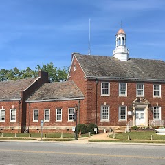
Shelby City Hall
Transit and Meeting Points
Useful pickup, handoff, or rendezvous points close to Kings Mountain.
Gastonia
Charlotte
Spartanburg
Kannapolis
Flight Path Map
This map shows the direct air route between Aberdeen and Chapel Hill. Straight-line distance: 192.69 mi (310.11 km).

#1 Aberdeen
Town in Moore County, North Carolina, United States
| Population | 8,339 |
| Coordinates | 35.1315500, -79.4294800 |
| Altitude | 105 |
| Country | United States |

#2 Chapel Hill
Town in Orange County, North Carolina, United States
| Population | 63,705 |
| Coordinates | 35.9428800, -82.7087500 |
| Altitude | 658 |
| Country | United States |
End: (-82.708707, 35.942917)
Estimated Travel Time
Distance: 411 km by road
| Speed | Time |
|---|---|
| 30 mph (48.3 km/h) | 08h 30m |
| 40 mph (64.37 km/h) | 06h 22m |
| 50 mph (80.47 km/h) | 05h 06m |
| 60 mph (96.56 km/h) | 04h 15m |
| 70 mph (112.65 km/h) | 03h 38m |
| 80 mph (129 km/h) | 03h 11m |
Fuel, Round Trip and CO2
Estimated fuel cost and emissions for this route.
| Fuel | $/gal | One way | Round trip |
|---|---|---|---|
| Regular gas | $3.96 | $35.69 | $71.38 |
| Mid-grade | $4.43 | $39.91 | $79.81 |
| Premium | $4.78 | $43.05 | $86.10 |
| Diesel | $5.62 | $50.67 | $101.34 |
Assumes 8.3 L/100 km (about 28.3 MPG). CO2 is an estimate and varies by vehicle, fuel blend, traffic, and terrain.
Prices in North Carolina · Jun 19, 2026
Distance to Other Cities
Planning a road trip? See the full trip guide on Trip.ovh — stops, fuel costs, weather, and departure timing.