Ardsley, New York
Ardsley: village in New York
About
Ardsley is a village located in the county of Westchester in the U.S. state of New York. Its population at the 2010 census was 4,452 and a population density of 1,300 people per km². After 10 years in 2020 city had an estimated population of 4,502 inhabitants.

Quick Facts about Ardsley
| Population | 4,502 (2020) |
| Country | United States of America |
| State | New York (United States) |
| County | Westchester County |
| Postal code | 10502 |
| Area | 3.43 km2 |
| Latitude & Longitude | 41.0107,-73.8438 |
| Altitude | 210 feet / 64 meters |
| Time Zone | Eastern Time Zone |
| Local time | 04:17:33 (18th July 2026) |
| Density | 1,314 Pop. per km² as of 2020 |
| Population growth | 1.11% (2010-2020) |
| Weather | 83℉ Areas Of Smoke 7-days weather |

Geography
Ardsley is located at 41°0'38"N 73°50'38"W (41.0106500, -73.8437500).
Ardsley map
Weather
Areas of smoke before 11am, then areas of smoke and showers and thunderstorms between 11am and 3pm, then patchy smoke and showers and thunderstorms. M...
7-Day ForecastDemographics
The population of Ardsley increased by 1.11% in 10 years.
| Year | Population | % Change | Method |
|---|---|---|---|
| 2010 | 4,452 | - | census |
| 2011 | 4,414 | -0.86% | estimation process |
| 2012 | 4,421 | 0.16% | estimation process |
| 2013 | 4,443 | 0.5% | estimation process |
| 2014 | 4,451 | 0.18% | estimation process |
| 2015 | 4,516 | 1.44% | estimation process |
| 2016 | 4,527 | 0.24% | estimation process |
| 2017 | 4,505 | -0.49% | estimation process |
| 2018 | 4,494 | -0.24% | estimation process |
| 2019 | 4,502 | 0.18% | estimation process |
| 2020 | 4,502 | 0% | estimation process |
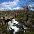
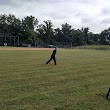
Best Things to Do in Ardsley
1V.E Macy Park
Saw Mill River Rd, Ardsley, NY 10502, United States View details
Phone: +19149468133 | Website available
2Louis Pascone Memorial Park
Ardsley, NY 10502, United States View details
Website available

3McDowell Park
Heatherdell Rd, Ardsley, NY 10502, United States View details
Phone: +19146931550 | Website available
4Grave of Jason Mizell
280 Secor Rd, Ardsley, NY 10502, United States View details
5Grave of Ed Sullivan
280 Secor Rd, Ardsley, NY 10502, United States View details
People born in Ardsley (1)
American architect Georgina Pope Yeatman was born in Ardsley
Nearby Schools and Colleges
Schools and campuses linked to Ardsley, NY. Select a name to open its map and contact details.
| Code | Name | City | ZIP |
|---|---|---|---|
| 193016 | Mercy College | Dobbs Ferry (NY) | 10522 |
Nearby Transit Stations (18)
Rail and bus stations connected to Ardsley, NY. Select a station to open its map and address details.
| Code | Name | Address | Type |
|---|---|---|---|
| YNY | Yonkers station | 5 Buena Vista Ave. | RAIL |
| NRO | New Rochelle station | 1 Railroad Plaza | RAIL |
| CRT | Croton–Harmon station | 1 Croton Point Avenue | RAIL |
| STM | Stamford Transportation Center | Washington Blvd and South State St. | RAIL |
| NYP | Pennsylvania Station | 8th Ave 31st Street / 8th Ave 33rd Street | RAIL |
Closest post offices linked to Ardsley.
| Post Office Name | City | ZIP |
|---|---|---|
| Ardsley Post Office | Ardsley (NY) | 10502 |
Other cities in Westchester County
Cities, towns, neighborhoods & other populated places in Westchester County , NY. (more)
| City Name | Population | Title |
|---|---|---|
| Yonkers | 200,040 | The second most populous city in Westchester County, New York. |
| Greenburgh | 90,543 | Town |
| New Rochelle | 80,973 | A city in Westchester County, New York. |
| Mount Vernon | 68,628 | The most populous city in Westchester County, New York. |
| White Plains | 58,286 | The most populous city in Westchester County, New York. |
| Rye | 46,100 | A town in Westchester County, New York. |
| Ossining | 37,551 | Town in Westchester County, New York, United States |
| Yorktown | 35,988 | Town in New York |
| Spring Valley | 32,258 | Village in New York, United States |
| Mamaroneck | 29,343 | Town in Westchester County, New York |
| Harrison | 28,959 | Community (coterminous town-village) in Westchester County, New York |
| Port Chester | 28,857 | Village in Westchester County, New York |
| Peekskill | 24,087 | City in Westchester County, New York, United States |
| Somers | 21,476 | Town in New York, US |
| Scarsdale | 17,785 | Town and village in Westchester County, New York, United States |
| Bedford | 17,450 | Town in Westchester County, New York, United States |
Distance to Other Cities
Ardsley distances to largest New York cities