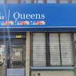
Queens, New York
Queens: The most populous borough of New York City. It is located in the eastern part of the city, on Long Island. Queens is a diverse borough, home to people from all over the world.
About
Queens is a city located in the county of Queens in the U.S. state of New York. Its population at the 2010 census was 2,234,935 and a population density of 4,848 people per km². After 5 years in 2015 city had an estimated population of 2,339,150 inhabitants.
The city was created 341 years ago in 1682.
Queens is one of the five boroughs of New York City. With over 2.4 million residents as of July 29, 2023, it is the second most populous borough after Brooklyn. Here are some key facts about Queens:
Location & Geography
Queens stretches across the western portion of Long Island and includes Jamaica Bay. It is bordered by Nassau County to the east, Brooklyn to the west, and Manhattan to the north.
Neighborhoods
Queens contains diverse neighborhoods like Astoria, Long Island City, Jackson Heights, Flushing, and Jamaica. Each has its own unique culture and demographics.
Diversity
Queens is one of the most ethnically diverse urban areas in the world. Around 138 languages are spoken by its residents, including Spanish, Chinese, Korean, Russian, and more.
Economy
JFK International Airport is located in Queens. Major industries include food processing, technology, transportation, retail, and construction. Large companies like JetBlue and Silvercup Studios operate in the borough.
Attractions
Top attractions in Queens include the Museum of the Moving Image, USTA Billie Jean King National Tennis Center, Citi Field baseball stadium, and Flushing Meadows Corona Park.
In summary, Queens is an extremely diverse borough and hub for immigration and multiculturalism within New York City. It offers distinct neighborhoods and a range of economic opportunities.

Quick Facts about Queens
| Population : | 2,339,150 (2015) |
| Country : | United States of America |
| State : | New York (United States) |
| County : | Queens County |
| Postal code : | 110-- |
| Phone Area Codes : | 347, 718, 917 |
| Area : | 461 km2 |
| Named for : | Catherine of Braganza |
| Establishment : | January 01, 1683 (341 years ago) |
| Time Zone : | Eastern Time Zone, UTC−05:00 |
| Local time : | 17:56:00 (25th April 2024) |
| Density : | 5,074 Pop. per km² as of 2015 |
| Population growth : | 4.46% (2010-2015) |

Geography
Queens is located at 40°40'53"N 73°50'11"W (40.6814900, -73.8365200). It has 3 neighbors: Manhattan, The Bronx and Brooklyn.
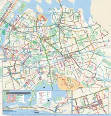
Queens map
- Official Website
Official website of Queens
Melinda Katz ,
Queens has 3 neighbours.
- Manhattan borough of New York City, New York, United States
- The Bronx The fourth most populous borough of New York City. It is located in the northern part of the city, on the mainland of New York State. The Bronx is home to Yankee Stadium, the home of the New York Yankees baseball team.
- Brooklyn borough of New York City, New York, United States
- Jamaica
- Long Island City
- Jackson Heights
- Cambria Heights
- Flushing
Demographics
The population of Queens increased by 4.46% in 5 years.
| Year | Population | % Change | Method |
| 2010 | 2,234,935 | - | estimation process |
| 2011 | 2,257,837 | 1.01% | estimation process |
| 2012 | 2,275,889 | 0.79% | estimation process |
| 2013 | 2,296,175 | 0.88% | estimation process |
| 2015 | 2,339,150 | 1.84% | demographic balance |
Best Things to Do in Queens
1 New York Hall Of Science
47-01 111th St, Queens, NY 11368, United States ➦ Show Map
☎ +17186990005 🔗 Url
2 Queens Zoo
53-51 111th St, Queens, NY 11368, United States ➦ Show Map
☎ +17182711500 🔗 Url
3 Unisphere
Avenue of the Americas, Queens, NY 11354, United States ➦ Show Map
☎ 🔗 Url

4 Queens County Farm Museum
73-50 Little Neck Pkwy, Queens, NY 11004, United States ➦ Show Map
☎ +17183473276 🔗 Url
5 Queens Botanical Garden
43-50 Main St, Queens, NY 11355, United States ➦ Show Map
☎ +17188863800 🔗 Url

Other Places in Queens
1 New York City Department of Education
28-11 Queens Plaza N, Queens, NY 11101, United States ➦ Show Map
☎ +17183918300 🔗 Url
2 New York City Council
37-32 75th St, Queens, NY 11372 ➦ Show Map
☎ +17188036373 🔗 Url
3 Family Welcome Center (NYCDOE Enrollment for Districts 25 and 26)
30-48 Linden Pl 2nd floor, Queens, NY 11354, United States ➦ Show Map
☎ +17189353500 🔗 Url
4 Queens Hospital WIC Program
79-18 164th St, Queens, NY 11432, United States ➦ Show Map
☎ +17188834868 🔗 Url
People born in Queens (200)
People born in Queens, including rapper and record producer Large Professor, film producer Albert R. Broccoli, politician James Lent, .
List
- Spider-Man (Marvel Comics superhero)
- George J. Hochbrueckner (American politician) he was born in 20/09/1938
- John J. Morgan (American politician (1770-1849)) he was born in 01/01/1770
- Paulette Goddard (American actress) she was born in 03/06/1910
- Melanie Safka (American singer) she was born in 03/02/1947
- Stephen Jay Gould (American evolutionary biologist) he was born in 10/09/1941
- Peter Facinelli (American actor) he was born in 26/11/1973
- Debra Wilson (American actress) she was born in 26/04/1962
- Hank Azaria (American actor) he was born in 25/04/1964
- Allyson Schwartz (American politician) she was born in 03/10/1948
- Doron Lamb (American basketball player) he was born in 06/11/1991
- Dennis Tito (American businessman) he was born in 08/08/1940
- Jesse Eisenberg (American actor) he was born in 05/10/1983
- Ray Romano (American stand-up comedian) he was born in 21/12/1957
- Bernadette Peters (Actress, singer) she was born in 28/02/1948
- Elizabeth Perkins (American actress) she was born in 18/11/1960
- Patty Duke (American actress and health advocate (1946-2016)) she was born in 14/12/1946
- Mercedes Ruehl (American actress) she was born in 28/02/1948
Schools in Queens
College & universities near Queens, NY
| Code | Name | City | ZIP |
|---|---|---|---|
| 197692 | Yeshiva Shaar Hatorah | Kew Gardens (NY) | 11418 |
| 189255 | Berkowits School of Electrolysis | Forest Hills (NY) | 11375-6820 |
| 415987 | Allen School-Jamaica | Jamaica (NY) | 11432 |
| 194499 | Plaza College | Forest Hills (NY) | 11375 |
| 190691 | CUNY York College | Jamaica (NY) | 11451 |
Stations (15)
Amtrak & bus stations near Queens, NY
| Code | Name | Address | Type |
|---|---|---|---|
| NYP | Pennsylvania Station | 8th Ave 31st Street / 8th Ave 33rd Street | RAIL |
| NRO | New Rochelle station | 1 Railroad Plaza | RAIL |
| NWK | Pennsylvania Station | 1 Raymond Plaza West | RAIL |
| YNY | Yonkers station | 5 Buena Vista Ave. | RAIL |
| EWR | Newark Liberty International Airport | Newark Liberty International Airport | RAIL |
Post offices near Queens
| Post Office Name | City | ZIP |
|---|---|---|
| Ozone Park Post Office | Ozone Park (NY) | 11417 |
| South Richmond Hill Post Office | South Richmond Hill (NY) | 11419 |
| Station B Post Office | Howard Beach (NY) | 11414 |
| Richmond Hill Post Office | Richmond Hill (NY) | 11418 |
| South Ozone Park Post Office | South Ozone Park (NY) | 11420 |
Other cities in Queens County
Cities, towns, neighborhoods & other populated places in Queens County , NY.
| City Name | Population | Title |
|---|---|---|
| Jamaica | 216,866 | A neighborhood in Queens, New York City. |
| Richmond Hill | 98,984 | A hamlet in the Town of Mount Pleasant, New York. |
| Hillside | 24,808 | Census-designated place in Ulster County, New York |
| Arverne | 14,120 | Neighborhood in Queens, New York City |
| Roxbury | 2,296 | Town in Delaware County, New York |
Distance to Other Cities
Queens distances to largest New York cities
- New York City
- Brooklyn
- Manhattan
- The Bronx
- Staten Island
- Buffalo
- Babylon
- Jamaica
- Yonkers
- East Flatbush
- Syracuse
- Richmond Hill
- Albany
- New Rochelle
- Mount Vernon
- Schenectady
- Utica
- White Plains
Map & Images (more maps)