Lesotho (Kingdom of Lesotho), LS
Lesotho: Independent country in southern Africa
About

Quick Facts about Kingdom of Lesotho
| Population : | 2,233,339 |
| Country : | Lesotho |
| Head of government : | Prime Minister of Lesotho |
| Plate code : | LS |
| Official name : | Kingdom of Lesotho, le Royaume du Lesotho, Lesotho, Lesotho, Muso oa Lesotho |
| Continent : | Africa |
| Easternmost point : | Point(29.45546 -29.34096) |
| Northernmost point : | Point(28.65 -28.57) |
| Legislative body : | Parliament of Lesotho |
| Named for : | Sesotho |
| Official language : | English, Sesotho |
| Capital : | Maseru |
| Establishment : | January 01, 1966 (58 years ago) |
| Time Zone : | UTC+02:00 |
| Local time : | 15:30:15 (19th April 2024) |

Geography
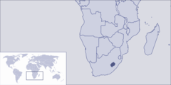
Kingdom of Lesotho is located at 29°30'0"S 28°15'0"E (-29.5000000, 28.2500000).
Lesotho map
Click "full screen"  icon to open full mode. View satellite images
The largest city of Kingdom of Lesotho is Maseru with a population of 330,790. Other cities include, Mafeteng population 57,059, Quthing population 24,130, Butha-Buthe population 16,330 and Mokhotlong population 8,809. See all Kingdom of Lesotho cities & populated places.
- Official Website
Official website of Kingdom of Lesotho
Moeketsi Majoro ,
- Qacha's Nek District
- Maseru District
- Butha-Buthe District
- Quthing District
- Mokhotlong District
- Berea District
- Thaba-Tseka District
- Mafeteng District
- Leribe District
- Mohale's Hoek District
Demographics
| Year | Population | % Change | Method |
| 1960 | 851,412 | - | census |
| 1961 | 866,253 | 1.71% | census |
| 1962 | 881,910 | 1.78% | census |
| 1963 | 898,342 | 1.83% | census |
| 1964 | 915,473 | 1.87% | census |
| 1965 | 933,251 | 1.9% | census |
| 1966 | 951,736 | 1.94% | census |
| 1967 | 970,972 | 1.98% | census |
| 1968 | 990,869 | 2.01% | census |
| 1969 | 1,011,308 | 2.02% | census |
| 1970 | 1,032,240 | 2.03% | census |
| 1971 | 1,053,524 | 2.02% | census |
| 1972 | 1,075,281 | 2.02% | census |
| 1973 | 1,098,033 | 2.07% | census |
| 1974 | 1,122,484 | 2.18% | census |
| 1975 | 1,149,090 | 2.32% | census |
| 1976 | 1,177,975 | 2.45% | census |
| 1977 | 1,208,836 | 2.55% | census |
| 1978 | 1,241,159 | 2.6% | census |
| 1979 | 1,274,216 | 2.59% | census |
| 1980 | 1,307,403 | 2.54% | census |
| 1981 | 1,340,694 | 2.48% | census |
| 1982 | 1,374,044 | 2.43% | census |
| 1983 | 1,406,818 | 2.33% | census |
| 1984 | 1,438,248 | 2.19% | census |
| 1985 | 1,467,856 | 2.02% | census |
| 1986 | 1,495,101 | 1.82% | census |
| 1987 | 1,520,244 | 1.65% | census |
| 1988 | 1,544,580 | 1.58% | census |
| 1989 | 1,569,936 | 1.62% | census |
| 1990 | 1,597,534 | 1.73% | census |
| 1991 | 1,627,900 | 1.87% | census |
| 1992 | 1,660,360 | 1.95% | census |
| 1993 | 1,693,459 | 1.95% | census |
| 1994 | 1,725,118 | 1.84% | census |
| 1995 | 1,753,824 | 1.64% | census |
| 1996 | 1,779,197 | 1.43% | census |
| 1997 | 1,801,679 | 1.25% | census |
| 1998 | 1,821,609 | 1.09% | census |
| 1999 | 1,839,611 | 0.98% | census |
| 2000 | 1,856,225 | 0.9% | census |
| 2001 | 1,871,500 | 0.82% | census |
| 2002 | 1,885,487 | 0.74% | census |
| 2003 | 1,898,757 | 0.7% | census |
| 2004 | 1,912,022 | 0.69% | census |
| 2005 | 1,925,844 | 0.72% | census |
| 2006 | 1,940,413 | 0.75% | census |
| 2007 | 1,955,784 | 0.79% | census |
| 2008 | 1,972,199 | 0.83% | census |
| 2009 | 1,989,873 | 0.89% | census |
| 2010 | 2,008,921 | 0.95% | census |
| 2011 | 2,029,516 | 1.01% | census |
| 2012 | 2,051,545 | 1.07% | census |
| 2013 | 2,074,465 | 1.1% | census |
| 2014 | 2,043,437 | -1.52% | (Worldbank) |
| 2015 | 2,059,021 | 0.76% | (Worldbank) |
| 2016 | 2,075,001 | 0.77% | (Worldbank) |
| 2017 | 2,233,339 | 7.09% | census |
| 2018 | 2,108,132 | -5.94% | (Worldbank) |
| 2019 | 2,125,268 | 0.81% | (Worldbank) |
Basoetoland, Colony of Basutoland, Kingdom of Lesotho, Le-xo-tho, Le-xo-tho (Lesotho), Leasoto, Leosota, Leosóta, Leshoto, Lesoso, Lesota, Lesotas, Lesotho, Lesothu, Lesothum, Lesothô, Lesoto, Lesuto, Lesòto, Lesótó, Lesôtho, Losooto, Lê-xô-thô, Lê-xô-thô (Lesotho), Lɛsoto nutome, Lɛsutu, Orileede Lesoto, Orílẹ́ède Lesoto, Sutuvaen, Sutuvän, i-Lesotho, lai suo tuo, le so tho, lecoto, leseattea, lesotho, lesoto, lethoso, lswtw, lyswtw, pra thes le so tho, resoto, resoto wang guo, Λεσόθο, Λεσότο, Лесота, Лесото, Лешото, Լեսոտո, לסוטו, לסותו, لسوتو, ليسوتو, لیسوتھو, لېسوتو, لەسۆتۆ, लेसोथो, লেসোথো, લેસોથો, ଲେସୋଥୋ, லெசோதோ, లెసోతో, ಲೆಥೋಸೊ, ലെസോത്തോ, ประเทศเลโซโท, เลโซโท, ເລໂຊໂທ, ལེ་སོ་ཐོ།, ლესოთო, ლესოტო, ሌሶቶ, លើសូតូ, レソト, レソト王国, 莱索托, 레소토
Map & Images (more maps)
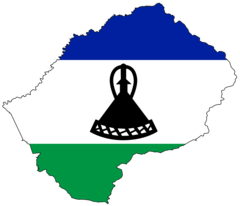
Lesotho Flag Map
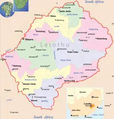
Leshoto Political Map